IMAGES TAKEN NEAR TO
Ballifeary Road, INVERNESS, IV3 5PE
Introduction
This page details the photographs taken nearby to Ballifeary Road, IV3 5PE by members of the Geograph project.
The Geograph project started in 2005 with the aim of publishing, organising and preserving representative images for every square kilometre of Great Britain, Ireland and the Isle of Man.

There are currently over 7.5m images from over14,400 individuals and you can help contribute to the project by visiting https://www.geograph.org.uk
Image Map (Loading...)


Getting Data...Please wait
Leaflet Map data © OpenStreetMap
Images are licensed for reuse under creativecommons.org/licenses/by-sa/2.0
Notes
- Clicking on the map will re-center to the selected point.
- The higher the marker number, the further away the image location is from the centre of the postcode.
Image Listing (56 Images Found)
Images are licensed for reuse under creativecommons.org/licenses/by-sa/2.0
Image
Details
Distance
2
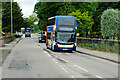
Stagecoach Bus on Glenurquhart Road at Inverness
Stagecoach West Scotland's Alexander Dennis Enviro400, SN16 OMD (19517) operating on route number 17 to Inverness.
Image: © David Dixon
Taken: 21 Jun 2022
0.07 miles
3
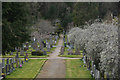
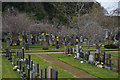
Inverness : Tomnahurich Cemetery
Tomnahurich Cemetery is laid out along the summit and slopes of Tomnahurich Hill, 1.5km south-east of Inverness city centre. Its western boundary is formed by the Caledonian Canal and its eastern and southern boundaries by Glenurquhart Road (A82).
Image: © Lewis Clarke
Taken: 24 Apr 2016
0.07 miles
4
Inverness : Tomnahurich Cemetery
Tomnahurich Cemetery is laid out along the summit and slopes of Tomnahurich Hill, 1.5km south-east of Inverness city centre. Its western boundary is formed by the Caledonian Canal and its eastern and southern boundaries by Glenurquhart Road (A82).
Image: © Lewis Clarke
Taken: 24 Apr 2016
0.07 miles
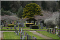
5
Inverness : Tomnahurich Cemetery
Tomnahurich Cemetery is laid out along the summit and slopes of Tomnahurich Hill, 1.5km south-east of Inverness city centre. Its western boundary is formed by the Caledonian Canal and its eastern and southern boundaries by Glenurquhart Road (A82).
Image: © Lewis Clarke
Taken: 24 Apr 2016
0.08 miles
6
Inverness : Tomnahurich Cemetery
Tomnahurich Cemetery is laid out along the summit and slopes of Tomnahurich Hill, 1.5km south-east of Inverness city centre. Its western boundary is formed by the Caledonian Canal and its eastern and southern boundaries by Glenurquhart Road (A82).
Image: © Lewis Clarke
Taken: 24 Apr 2016
0.08 miles
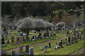
7
Tomnahurich Cemetery
A newer part of the cemetery. The cemetery includes the wooded hill behind, and is a very large one.
Image: © Bill Boaden
Taken: 27 Jul 2013
0.08 miles
8
Inverness : Tomnahurich Cemetery
Tomnahurich Cemetery is laid out along the summit and slopes of Tomnahurich Hill, 1.5km south-east of Inverness city centre. Its western boundary is formed by the Caledonian Canal and its eastern and southern boundaries by Glenurquhart Road (A82).
Image: © Lewis Clarke
Taken: 24 Apr 2016
0.08 miles
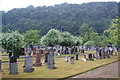
9
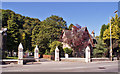
Entrance to Tomnahurich Cemetery
This is the entrance from Glenurquhart Road. The cemetery is large, with burials all round and over the tree-covered Tomnahurich Hill. The cemetery was developed between the mid 19th to mid 20th centuries.
Image: © Richard Dorrell
Taken: 27 Aug 2014
0.09 miles
10
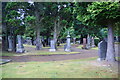
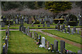
Tomnahurich Cemetery
A large and long-established cemetery with many old and grand graves.
Image: © Bill Boaden
Taken: 27 Jul 2013
0.09 miles