IMAGES TAKEN NEAR TO
Bruce Avenue, INVERNESS, IV3 5HE
Introduction
This page details the photographs taken nearby to Bruce Avenue, IV3 5HE by members of the Geograph project.
The Geograph project started in 2005 with the aim of publishing, organising and preserving representative images for every square kilometre of Great Britain, Ireland and the Isle of Man.

There are currently over 7.5m images from over14,400 individuals and you can help contribute to the project by visiting https://www.geograph.org.uk
Image Map
Images are licensed for reuse under creativecommons.org/licenses/by-sa/2.0
Notes
- Clicking on the map will re-center to the selected point.
- The higher the marker number, the further away the image location is from the centre of the postcode.
Image Listing (38 Images Found)
Images are licensed for reuse under creativecommons.org/licenses/by-sa/2.0
Image
Details
Distance
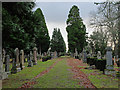
1
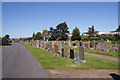
Tomnahurich cemetery
This is just a small part in the north east of this very large cemetery. Burials began here in the mid 19th century and continued until the mid 20th century. In this view, the housing in the background is in Bruce Avenue.
Image: © Richard Dorrell
Taken: 27 Aug 2014
0.04 miles
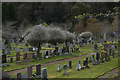
2
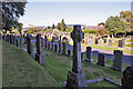
Tomnahurich cemetery
Headstones and monuments of all shapes and sizes mark the thousands of graves in this large cemetery. The cemetery was developed between the mid 18th and mid 19th centuries. It is immaculately maintained.
Image: © Richard Dorrell
Taken: 27 Aug 2014
0.05 miles
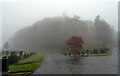
3
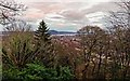
View over Inverness
View over Inverness to the Kessock Bridge from the Tomnahurich Cemetery
Image: © valenta
Taken: 1 Jan 2018
0.08 miles
4
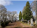
Top of Tomnahurich
Looking north along the flat area on top of the hill. It appears this is an older part of the cemetery, with a variety of gravestones and tall trees.
Image: © Craig Wallace
Taken: 23 Mar 2015
0.12 miles
5
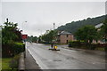
Glenurquhart Road, Inverness
Seen on a wet day.
Image: © Bill Boaden
Taken: 27 Jul 2013
0.12 miles
6
Inverness : Tomnahurich Cemetery
Tomnahurich Cemetery is laid out along the summit and slopes of Tomnahurich Hill, 1.5km south-east of Inverness city centre. Its western boundary is formed by the Caledonian Canal and its eastern and southern boundaries by Glenurquhart Road (A82).
Image: © Lewis Clarke
Taken: 24 Apr 2016
0.12 miles
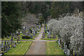
8
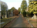
Grand avenue in Tomnahurich Cemetery
The main paths in the cemetery form a perfect cross.
Image: © Douglas Nelson
Taken: 11 Mar 2023
0.12 miles
9
On top of Tom na h-Iurach
Some of the oldest graves in Inverness's Tomnahurich cemetery are here on the flattened summit of the hill. The hill itself is an isolated, 65m high, glacial deposit feature (a large drumlin?).
Image: © John Allan
Taken: 23 Jan 2014
0.12 miles
10
Inverness : Tomnahurich Cemetery
Tomnahurich Cemetery is laid out along the summit and slopes of Tomnahurich Hill, 1.5km south-east of Inverness city centre. Its western boundary is formed by the Caledonian Canal and its eastern and southern boundaries by Glenurquhart Road (A82).
Image: © Lewis Clarke
Taken: 24 Apr 2016
0.13 miles