IMAGES TAKEN NEAR TO
Montague Row, INVERNESS, IV3 5DX
Introduction
This page details the photographs taken nearby to Montague Row, IV3 5DX by members of the Geograph project.
The Geograph project started in 2005 with the aim of publishing, organising and preserving representative images for every square kilometre of Great Britain, Ireland and the Isle of Man.

There are currently over 7.5m images from over14,400 individuals and you can help contribute to the project by visiting https://www.geograph.org.uk
Image Map
Images are licensed for reuse under creativecommons.org/licenses/by-sa/2.0
Notes
- Clicking on the map will re-center to the selected point.
- The higher the marker number, the further away the image location is from the centre of the postcode.
Image Listing (210 Images Found)
Images are licensed for reuse under creativecommons.org/licenses/by-sa/2.0
Image
Details
Distance
1

Planefield Bowling Club
A bowling green on Planefield Road, in Inverness. The club was established in 1926.
http://www.planefieldbowlingclub.co.uk/
Image: © Craig Wallace
Taken: 21 Feb 2019
0.05 miles
3
Inverness High School showing Cut Mark
Inverness High School, showing Ordnance Survey Cut Mark, bottom right of doorway in the chocolate coloured paint
CUT MARK: INVERNESS HIGH SCH SE FACE 12M E ANG (ODN 8.1472m, AGL 0.3m).
Image: © thejackrustles
Taken: 7 Jul 2015
0.06 miles
4
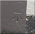
OS Cut Mark - Inverness, Inverness High School
CUT MARK: INVERNESS HIGH SCH SE FACE 12M E ANG (ODN 8.1472m, AGL 0.3m).
Image: © thejackrustles
Taken: 7 Jul 2015
0.06 miles
5
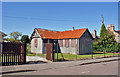
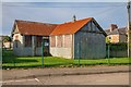
Disused building
This small building with corrugated iron roof is boarded up and fenced in. It has the look of having once been a chapel. It is possible that the walls are faced with corrugated asbestos, which for health and safety reasons, would be expensive to remove, and may explain why the building stands untouched.
Image: © Richard Dorrell
Taken: 27 Aug 2014
0.07 miles
6
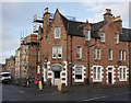
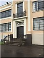
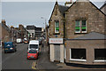
The Bakery, Tomnahurich Street
At the junction of Tomnahurich Street and Montague Row. On the ground floor is The Bakery, with a pair of postboxes to the left.
The stone on top of the building says AMcD 1888.
Last week there was debris falling from the roof, with concerns for an unstable chimney. There is now scaffolding up, and the pavement is fenced off.
https://www.pressandjournal.co.uk/fp/news/highlands/1652619/road-closure-after-debris-falls-property-on-montague-row/
Image: © Craig Wallace
Taken: 23 Jan 2019
0.07 miles
7
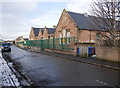
Central Primary School, Planefield Road
The back of Central Primary School, on Planefield Road.
Image: © Craig Wallace
Taken: 23 Jan 2019
0.07 miles
8
Former Inverness School
This corrugated iron building was once a school, but as the population increased it was replaced by this building, quite a contrast Image]
Image: © valenta
Taken: 6 Feb 2020
0.07 miles
9
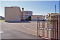
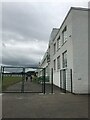
Inverness High School
A peep in through the entrance from Montague Row. The school has a roll of about 410 pupils. It moved to this site in 1937, though the gates at this entrance commemorate the coronation of Queen Elizabeth II in 1953.
Image: © Richard Dorrell
Taken: 27 Aug 2014
0.07 miles
10
Inverness : Tomnahurich Street
Looking along a busy road through Inverness.
Image: © Lewis Clarke
Taken: 24 Apr 2016
0.08 miles