IMAGES TAKEN NEAR TO
Planefield Road, INVERNESS, IV3 5DN
Introduction
This page details the photographs taken nearby to Planefield Road, IV3 5DN by members of the Geograph project.
The Geograph project started in 2005 with the aim of publishing, organising and preserving representative images for every square kilometre of Great Britain, Ireland and the Isle of Man.

There are currently over 7.5m images from over14,400 individuals and you can help contribute to the project by visiting https://www.geograph.org.uk
Image Map
Images are licensed for reuse under creativecommons.org/licenses/by-sa/2.0
Notes
- Clicking on the map will re-center to the selected point.
- The higher the marker number, the further away the image location is from the centre of the postcode.
Image Listing (320 Images Found)
Images are licensed for reuse under creativecommons.org/licenses/by-sa/2.0
Image
Details
Distance
1

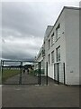
Planefield Bowling Club
A bowling green on Planefield Road, in Inverness. The club was established in 1926.
http://www.planefieldbowlingclub.co.uk/
Image: © Craig Wallace
Taken: 21 Feb 2019
0.03 miles
2
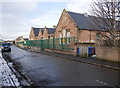
Central Primary School, Planefield Road
The back of Central Primary School, on Planefield Road.
Image: © Craig Wallace
Taken: 23 Jan 2019
0.03 miles
3
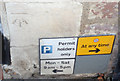
OSCut Mark, Inverness, Number 63 Tomnahurich Street
Ordnance Survey Cut Mark on 'Telly on the Blink' Shop
Image: © thejackrustles
Taken: 14 Oct 2014
0.06 miles
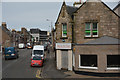
4
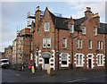
The Bakery, Tomnahurich Street
At the junction of Tomnahurich Street and Montague Row. On the ground floor is The Bakery, with a pair of postboxes to the left.
The stone on top of the building says AMcD 1888.
Last week there was debris falling from the roof, with concerns for an unstable chimney. There is now scaffolding up, and the pavement is fenced off.
https://www.pressandjournal.co.uk/fp/news/highlands/1652619/road-closure-after-debris-falls-property-on-montague-row/
Image: © Craig Wallace
Taken: 23 Jan 2019
0.06 miles
5
Inverness : Tomnahurich Street
Looking along a busy road through Inverness.
Image: © Lewis Clarke
Taken: 24 Apr 2016
0.06 miles
7
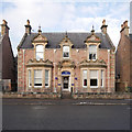
18 Ardross Street
Dating from 1885, probably designed by Robert Black. It is a Category C listed building. http://portal.historicenvironment.scot/designation/LB35142
It is now part of the Ardross Glencairn Guesthouse, along with number 19. https://www.ardrossglencairn.co.uk/
Image: © Craig Wallace
Taken: 23 Jan 2019
0.09 miles
8
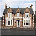
19 Ardross Street
Dating from 1887, probably designed by Robert Black. It is a Category C listed building. http://portal.historicenvironment.scot/designation/LB35143
It is now part of the Ardross Glencairn Guesthouse, along with number 18. https://www.ardrossglencairn.co.uk/
Image: © Craig Wallace
Taken: 23 Jan 2019
0.09 miles
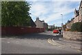
9

Inverness : Kenneth Street
Looking along Kenneth Street in Inverness.
Image: © Lewis Clarke
Taken: 24 Apr 2016
0.09 miles