IMAGES TAKEN NEAR TO
Innes Road, FOCHABERS, IV32 7NL
Introduction
This page details the photographs taken nearby to Innes Road, IV32 7NL by members of the Geograph project.
The Geograph project started in 2005 with the aim of publishing, organising and preserving representative images for every square kilometre of Great Britain, Ireland and the Isle of Man.

There are currently over 7.5m images from over14,400 individuals and you can help contribute to the project by visiting https://www.geograph.org.uk
Image Map (Loading...)


Getting Data...Please wait
Leaflet Map data © OpenStreetMap
Images are licensed for reuse under creativecommons.org/licenses/by-sa/2.0
Notes
- Clicking on the map will re-center to the selected point.
- The higher the marker number, the further away the image location is from the centre of the postcode.
Image Listing (43 Images Found)
Images are licensed for reuse under creativecommons.org/licenses/by-sa/2.0
Image
Details
Distance
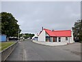
2
Shop Cottage
This windowless early 19th century cottage is a Category B Listed building. It is attached to the former village shop, which is hidden from this angle.
Image: © Anne Burgess
Taken: 23 Oct 2021
0.15 miles
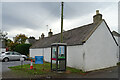
3
Road approaching Garmouth from the west
Image: © Steven Brown
Taken: 6 Oct 2010
0.16 miles
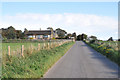
4
Looking towards Tugnet
The old water tower and the standing stones are at the top
of a hill, from which this was taken. The white house in the
distance is Tugnet House, in front of this is a bird watchers
paradise.
Image: © Ann Harrison
Taken: 2 Apr 2008
0.16 miles
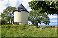
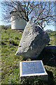
6
Water tower and Browlands Standing Stones
The now disused water tower was built in the late 1890s to provide a better water supply for Garmouth and Kingston. Now owned by the Garmouth and Kingston Community Association, it is Category B listed http://portal.historicenvironment.scot/designation/LB14838.
The standing stones are believed to be the remains of a burial site known as a 'four poster', dating from about 1500BC.
Image: © Richard Sutcliffe
Taken: 26 Dec 2023
0.16 miles
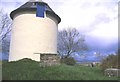
7

Old water tower
The now disused water tower was built in the late 1890s to provide a better water supply for Garmouth and Kingston. Now owned by the Garmouth and Kingston Community Association, it is Category B listed http://portal.historicenvironment.scot/designation/LB14838.
Image: © Richard Sutcliffe
Taken: 26 Dec 2023
0.16 miles
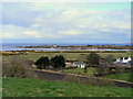
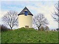
8
Garmouth Water Tower
The now disused water tower now offers a viewpoint over the flood plain of the River Spey.
Image: © Anne Burgess
Taken: 8 May 2005
0.16 miles
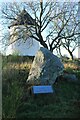
10
Browlands Standing Stones
The standing stones are thought by some to be the remains of a 'four-poster' type Neolithic stone circle, but Historic Environment Scotland isn't so sure. See https://canmore.org.uk/site/16949/browlands-garmouth for more details. Behind them is the Garmouth Water Tower, built at the end of the 19th century but no longer in use.
Image: © Anne Burgess
Taken: 24 Apr 2021
0.18 miles