IMAGES TAKEN NEAR TO
FOCHABERS, IV32 7LE
Introduction
This page details the photographs taken nearby to IV32 7LE by members of the Geograph project.
The Geograph project started in 2005 with the aim of publishing, organising and preserving representative images for every square kilometre of Great Britain, Ireland and the Isle of Man.

There are currently over 7.5m images from over14,400 individuals and you can help contribute to the project by visiting https://www.geograph.org.uk
Image Map
Images are licensed for reuse under creativecommons.org/licenses/by-sa/2.0
Notes
- Clicking on the map will re-center to the selected point.
- The higher the marker number, the further away the image location is from the centre of the postcode.
Image Listing (11 Images Found)
Images are licensed for reuse under creativecommons.org/licenses/by-sa/2.0
Image
Details
Distance
1
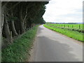
Minor road approaching Greshornish
Looking southward.
Image: © Peter Wood
Taken: 14 May 2022
0.15 miles
2
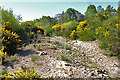
Abandoned River Channel
One of the many former channels of the shifting River Spey, though it looks as if this one is either relatively recent, or may have been active in a spate.
Image: © Anne Burgess
Taken: 7 May 2020
0.20 miles
3
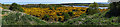
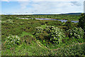
River Spey Flood Plain
This is the view down from the top of the steps in Image The flood plain is well covered by vegetation, mainly whins in the foreground, and deciduous woodland further away.
Compare this with a view from much the same spot a few weeks later Image
Image: © Anne Burgess
Taken: 7 May 2020
0.21 miles
4
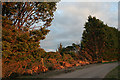
Shelter no more
The long shelter belt by the side of the minor road between Mosstodloch and Garmouth has been well and truly breached. Whether this was solely the result of the exceptional gales of 8 December 2011 and 3 January 2012 I am not sure.
Image: © Anne Burgess
Taken: 21 Mar 2012
0.22 miles
5
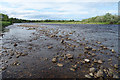
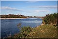
River Spey
The scattering of pebbles is the remains of what the map shows as a substantial shingle bank, almost washed away by the shifting river.
Image: © Anne Burgess
Taken: 22 Jun 2020
0.22 miles
6
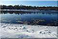
River Spey
Ice floes floating downriver on a deceptively peaceful reach of the River Spey.
Image: © Anne Burgess
Taken: 10 Feb 2021
0.22 miles
7
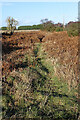
Faint Path
The path seeme to run parallel to the road.
Image: © Anne Burgess
Taken: 17 Feb 2021
0.23 miles
8
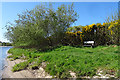
Riverbank Bench
Provided for anglers, but not in use at the moment because of the coronavirus lockdown which means people are not allowed to travel.
Image: © Anne Burgess
Taken: 7 May 2020
0.23 miles
9
River Spey
Compare with Image] which is much the same view a few weeks earlier.
Image: © Anne Burgess
Taken: 22 Jun 2020
0.25 miles
10
River Spey
A summery view on a winter day, looking downstream from in front of two fishing huts.
Image: © Anne Burgess
Taken: 24 Jan 2009
0.25 miles