IMAGES TAKEN NEAR TO
LOSSIEMOUTH, IV31 6SQ
Introduction
This page details the photographs taken nearby to IV31 6SQ by members of the Geograph project.
The Geograph project started in 2005 with the aim of publishing, organising and preserving representative images for every square kilometre of Great Britain, Ireland and the Isle of Man.

There are currently over 7.5m images from over14,400 individuals and you can help contribute to the project by visiting https://www.geograph.org.uk
Image Map (Loading...)


Getting Data...Please wait
Leaflet Map data © OpenStreetMap
Images are licensed for reuse under creativecommons.org/licenses/by-sa/2.0
Notes
- Clicking on the map will re-center to the selected point.
- The higher the marker number, the further away the image location is from the centre of the postcode.
Image Listing (8 Images Found)
Images are licensed for reuse under creativecommons.org/licenses/by-sa/2.0
Image
Details
Distance
1
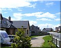
Muirton
The old farm buildings have been renovated and new dwellings have been built during the past twenty years, previously it was a farm with a caravan site.
Image: © Ann Harrison
Taken: 26 May 2009
0.04 miles
2
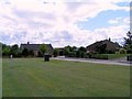
Muirton Court at Muirton
A hamlet between Lossiemouth and Elgin.
Image: © Ann Harrison
Taken: 26 May 2009
0.04 miles
3
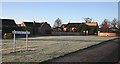
Muirton Court
Twenty-five years ago Muirton consisted of a farm house and a caravan site. It has been transformed into a hamlet of modern bungalows and the farm buildings have all been converted to houses.
Image: © Anne Burgess
Taken: 29 Nov 2008
0.05 miles
4
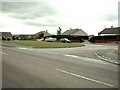
Muirtown near Lossiemouth
A small development of fairly new houses near RAF Lossiemouth
Image: © Christopher Gillan
Taken: 14 Apr 2006
0.09 miles
5
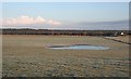
Ephemeral Pond near Muirton
Hoar frost still covers the grass by this frozen pond, the remnant of recent wet weather. To the left of the pond are a few brown specks which are in fact a flock of Curlews. The cottage is Paddockdale.
Image: © Anne Burgess
Taken: 29 Nov 2008
0.11 miles
6
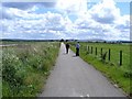
The Cycle Trail at Muirton
This trail was laid about three years ago and runs from
Lossiemouth to Elgin.
Image: © Ann Harrison
Taken: 26 May 2009
0.11 miles

8
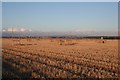
Fields near Cocklehill
Flat fields on the land reclaimed from the Loch of Spynie. Note that although the sun is shining brightly here, there is haar (sea mist) veiling the town of Lossiemouth in the distance.
Image: © Anne Burgess
Taken: 29 Nov 2008
0.23 miles