IMAGES TAKEN NEAR TO
Beils Brae, ELGIN, IV30 8XQ
Introduction
This page details the photographs taken nearby to Beils Brae, IV30 8XQ by members of the Geograph project.
The Geograph project started in 2005 with the aim of publishing, organising and preserving representative images for every square kilometre of Great Britain, Ireland and the Isle of Man.

There are currently over 7.5m images from over14,400 individuals and you can help contribute to the project by visiting https://www.geograph.org.uk
Image Map
Images are licensed for reuse under creativecommons.org/licenses/by-sa/2.0
Notes
- Clicking on the map will re-center to the selected point.
- The higher the marker number, the further away the image location is from the centre of the postcode.
Image Listing (24 Images Found)
Images are licensed for reuse under creativecommons.org/licenses/by-sa/2.0
Image
Details
Distance
1
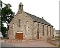
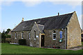
Former St Margaret's Free Kirk
The original 14th century parish kirk stood not far from here, but fell into disrepair when the new kirk on Gas Hill, north of the village, was built in 1843. This was the year of the Disruption of the Kirk, and the Free Kirk congregation used some of the stones from the old kirk to build this Free Kirk, named St Margaret's after the ancient Priory which stood near Clockeasy. The congregations merged again in 1838 and the kirk was sold in 1948. The door in the gable end has been enlarged to form a garage. (Thanks to James Denham for information about the building and its history.)
Image: © Anne Burgess
Taken: 11 Jun 2008
0.09 miles
2
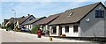
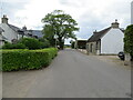
Beil's Brae
Modern housing in the village of Urquhart.
Image: © Anne Burgess
Taken: 14 Jul 2006
0.10 miles
3
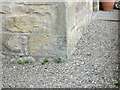
Ordnance Survey Cut Mark
This mark can be found on the wall of a former church building in Urquhart. Now a private dwelling called The Grain Dryer.
The recorded details give a height of 34.4833 metres above sea level.
For more detail see : https://www.bench-marks.org.uk/bm171451
Image: © Peter Wood
Taken: 14 May 2022
0.11 miles
4
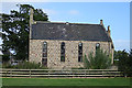
Former Free Kirk
This kirk was built in 1844 using stone from the old kirk of St Margaret in the kirkyard nearby. The architects were A and W Reid. It is now a house.
Image: © Anne Burgess
Taken: 15 Sep 2019
0.11 miles
5
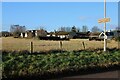
Station Road, Urquhart
Looking southward.
Image: © Peter Wood
Taken: 14 May 2022
0.12 miles
6
Houses, Urquhart
The rear of houses on Main Street.
Image: © Richard Sutcliffe
Taken: 29 Dec 2023
0.12 miles
7
Urquhart Church Hall
This was originally the Free Kirk school house, built in 1845. It contains stained glass windows from the former Free Kirk next door.
Image: © Anne Burgess
Taken: 15 Sep 2019
0.13 miles
8
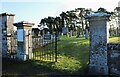
Entrance to the burial ground, Urquhart
The burial ground, which is Catgeory C listed https://portal.historicenvironment.scot/designation/LB14877, contains some interesting 18th, 19th and 20th century memorials and two 20th century war Commonwealth war graves.
Image: © Richard Sutcliffe
Taken: 29 Dec 2023
0.13 miles
9

Urquhart at Sunset
The setting sun picks out unevennesses in the growing crop just south of Urquhart.
Image: © Anne Burgess
Taken: 13 Jun 2008
0.14 miles
10
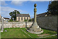
Urquhart Kirkyard
The elaborate cross commemorates the family of James Cooper, schoolmaster, and his wife Anne Reid, including their son James who became minister of St Nicholas East Kirk in Aberdeen. In the background is the former Free Kirk.
Image: © Anne Burgess
Taken: 15 Sep 2019
0.14 miles