IMAGES TAKEN NEAR TO
Moir Street, ELGIN, IV30 8UT
Introduction
This page details the photographs taken nearby to Moir Street, IV30 8UT by members of the Geograph project.
The Geograph project started in 2005 with the aim of publishing, organising and preserving representative images for every square kilometre of Great Britain, Ireland and the Isle of Man.

There are currently over 7.5m images from over14,400 individuals and you can help contribute to the project by visiting https://www.geograph.org.uk
Image Map
Images are licensed for reuse under creativecommons.org/licenses/by-sa/2.0
Notes
- Clicking on the map will re-center to the selected point.
- The higher the marker number, the further away the image location is from the centre of the postcode.
Image Listing (36 Images Found)
Images are licensed for reuse under creativecommons.org/licenses/by-sa/2.0
Image
Details
Distance
1
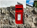
Postbox at Alves
IV30 104. Royal Mail list this box as 'IV30 Alves Village'.
Image: © David Bremner
Taken: 7 Oct 2022
0.04 miles
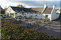
2
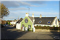
Calum's Kitchen
The former Crook Inn, which, sadly, was closed today because it's Monday and it is only open Tuesday to Sunday, so we couldn't stop for tea and cakes in the garden.
Image: © Anne Burgess
Taken: 16 Nov 2020
0.04 miles
3
Calum's Kitchen
The old Crook Inn, temporarily re-named the Crooked Inn, has changed hands again and is now Calum's Kitchen. We can vouch for the tea and cakes, which we enjoyed out of doors in the garden - in February!
Image: © Anne Burgess
Taken: 25 Feb 2020
0.04 miles
4
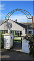
Calum's Kitchen
This archway is the entrance to the former Crook Inn from the main Road.
Image: © Anne Burgess
Taken: 25 Feb 2020
0.04 miles
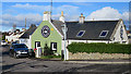
5
Calum's Kitchen
Outside tables and benches with a canopy have been installed to allow business to continue during the coronavirus pandemic, but perhaps it's now a bit late in the year for comfortable eating out of doors.
Image: © Anne Burgess
Taken: 16 Nov 2020
0.05 miles
6

The Crooked Inn
The full name of the village of Alves was Crook of Alves, the word 'crook' referring presumably to the corner where the Burghead Road joins the main road. The inn was appropriately called the Crook Inn, being on that corner. However it changed hands in the 1980s and was renamed the Crooked Inn, thereby discarding part of its history.
Image: © Anne Burgess
Taken: 1 Mar 2011
0.05 miles
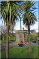
7
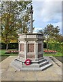
Alves Parish War Memorial
Unveiled and dedicated on 8th May 1921. WM Reference: 8698.
Image: © David Bremner
Taken: 7 Oct 2022
0.08 miles
8
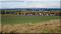
Crook of Alves
Although named simply as Alves on maps these days, older maps use the full name, Crook of Alves. From here, one is blissfully unaware of the busy A96 that carries heavy traffic along the edge of the village. The conspicuous green domes in the distance are biomass digesters at Wester Alves Farm. The name is pronounced AH-viss, by the way - the 'l' is silent and it has two syllables. Not 'alvz'.
Image: © Anne Burgess
Taken: 25 Feb 2020
0.08 miles
9
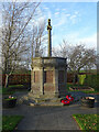
Alves War Memorial
Designed by John Wittet and erected in 1921, it has an octagonal plinth and a mercat cross type pillar.
Image: © Anne Burgess
Taken: 16 Nov 2020
0.08 miles
10
Alves War Memorial
A hexagonal plinth supports an old-fashioned cross shaft.
Image: © Anne Burgess
Taken: 25 Feb 2020
0.09 miles