IMAGES TAKEN NEAR TO
ELGIN, IV30 8TW
Introduction
This page details the photographs taken nearby to IV30 8TW by members of the Geograph project.
The Geograph project started in 2005 with the aim of publishing, organising and preserving representative images for every square kilometre of Great Britain, Ireland and the Isle of Man.

There are currently over 7.5m images from over14,400 individuals and you can help contribute to the project by visiting https://www.geograph.org.uk
Image Map
Images are licensed for reuse under creativecommons.org/licenses/by-sa/2.0
Notes
- Clicking on the map will re-center to the selected point.
- The higher the marker number, the further away the image location is from the centre of the postcode.
Image Listing (2 Images Found)
Images are licensed for reuse under creativecommons.org/licenses/by-sa/2.0
Image
Details
Distance
2
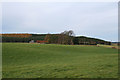
Nether Bogside
It is amazing how many farms bear the unappealing name of Bogside, hinting at land that is perhaps not the easiest to cultivate. The main farm is hidden among the trees, but one of the cottages is seen at left.
Image: © Anne Burgess
Taken: 21 May 2012
0.12 miles