IMAGES TAKEN NEAR TO
ELGIN, IV30 8TN
Introduction
This page details the photographs taken nearby to IV30 8TN by members of the Geograph project.
The Geograph project started in 2005 with the aim of publishing, organising and preserving representative images for every square kilometre of Great Britain, Ireland and the Isle of Man.

There are currently over 7.5m images from over14,400 individuals and you can help contribute to the project by visiting https://www.geograph.org.uk
Image Map (Loading...)


Getting Data...Please wait
Leaflet Map data © OpenStreetMap
Images are licensed for reuse under creativecommons.org/licenses/by-sa/2.0
Notes
- Clicking on the map will re-center to the selected point.
- The higher the marker number, the further away the image location is from the centre of the postcode.
Image Listing (4 Images Found)
Images are licensed for reuse under creativecommons.org/licenses/by-sa/2.0
Image
Details
Distance
2
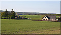
Houses at Easter Manbeen
The nearer houses, one traditional and one modern, are at Easter Manbeen, and Wester Manbeen is in the distance.
Image: © Anne Burgess
Taken: 21 May 2012
0.19 miles
3
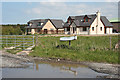
New Houses at Manbeen
These two houses are new enough not to be on the maps yet.
Image: © Anne Burgess
Taken: 21 May 2012
0.22 miles
4
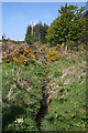
Drainage Ditch
The ditch here is fairly overgrown and will probably be nearly invisible in a few weeks' time. Taken from where the private road to Springburn crosses the ditch.
Image: © Anne Burgess
Taken: 21 May 2012
0.23 miles