IMAGES TAKEN NEAR TO
Torfness Place, ELGIN, IV30 5YS
Introduction
This page details the photographs taken nearby to Torfness Place, IV30 5YS by members of the Geograph project.
The Geograph project started in 2005 with the aim of publishing, organising and preserving representative images for every square kilometre of Great Britain, Ireland and the Isle of Man.

There are currently over 7.5m images from over14,400 individuals and you can help contribute to the project by visiting https://www.geograph.org.uk
Image Map
Images are licensed for reuse under creativecommons.org/licenses/by-sa/2.0
Notes
- Clicking on the map will re-center to the selected point.
- The higher the marker number, the further away the image location is from the centre of the postcode.
Image Listing (10 Images Found)
Images are licensed for reuse under creativecommons.org/licenses/by-sa/2.0
Image
Details
Distance
2
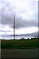
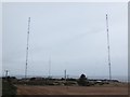
Radio Masts at Burghead
The radio masts prominent on the outskirts of Burghead.
Image: © Andrew Wood
Taken: 15 Jun 2009
0.14 miles
3
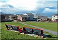
St Aethans View
A fine viewpoint in the St Aethans part of Burghead.
Image: © Mary and Angus Hogg
Taken: 24 Mar 2015
0.19 miles
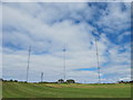
6
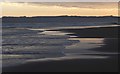
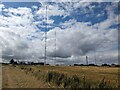
Radio Masts on Clarkly Hill
Taken from the sand spit at the mouth of the Findhorn river just after dawn.
Image: © Bob Embleton
Taken: 28 Aug 2007
0.22 miles
7
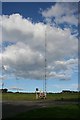
Burghead Radio Masts
These are two of the three masts just outside Burghead which transmit Radio 4 on long wave and Radio 5 and Radio Scotland on medium wave. The tallest of the three is about 240 metres tall.
Image: © Anne Burgess
Taken: 30 Sep 2010
0.22 miles
9
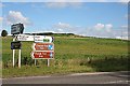
Signposts
A battery of signposts just outside Burghead. I have a niggling doubt that the state of preservation and amount of detailed interpretation of the Pictish fort are enough to justify such a prominent sign, but it must have been approved by the latest incarnation of the Scottish Tourist Board, VisitScotland (note the deliberate omission of the grammatically necessary space, in true keeping with the zeitgeist of the early 21st century!).
Image: © Anne Burgess
Taken: 30 Sep 2010
0.24 miles
10
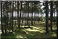
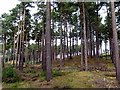
Roseisle Forest
The extensive forest plantations of Roseisle Forest border the B9089 as it passes through this square.
Image: © Anne Burgess
Taken: 30 Sep 2010
0.25 miles