IMAGES TAKEN NEAR TO
IV30 3PX
Introduction
This page details the photographs taken nearby to IV30 3PX by members of the Geograph project.
The Geograph project started in 2005 with the aim of publishing, organising and preserving representative images for every square kilometre of Great Britain, Ireland and the Isle of Man.

There are currently over 7.5m images from over14,400 individuals and you can help contribute to the project by visiting https://www.geograph.org.uk
Image Map
Images are licensed for reuse under creativecommons.org/licenses/by-sa/2.0
Notes
- Clicking on the map will re-center to the selected point.
- The higher the marker number, the further away the image location is from the centre of the postcode.
Image Listing (34 Images Found)
Images are licensed for reuse under creativecommons.org/licenses/by-sa/2.0
Image
Details
Distance
1
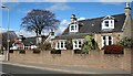
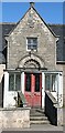
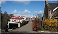
St Andrews Road, Lhanbryde
Houses on the north side of the main street of the village, now a peaceful spot since the village bypass was opened in 1995/6.
Image: © Anne Burgess
Taken: 5 Apr 2007
0.06 miles
2
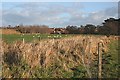
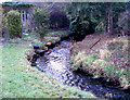
Railway Bridge near Lhanbryde
The bridge at the centre of this view carries the Aberdeen to Inverness railway line over a burn. Beyond the railway are some of the modern houses on the eastern outskirts of Lhanbryde.
Image: © Anne Burgess
Taken: 24 Nov 2008
0.09 miles
4
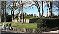
Lhanbryde Old Kirkyard
The Kirkyard is in the middle of the old village, though the church of the combined parish of St Andrews-Lhanbryd [the spelling is correct!] is a mile or two outside.
Image: © Anne Burgess
Taken: 5 Apr 2007
0.11 miles
6
Barra Lodge, St Andrews Road, Lhanbryde
My eye was caught by the architectural details of this house front, in particular the sculpture above the door and the patterns on the windows of the porch, though the latter is not of a piece with the rest if the house and is probably a later addition. The shield on the gable reads "B P 1851". The only adult male with initials B P in the parish in the 1851 and 1861 censuses was Benjamin Pennycuick, a forester from Lasswade in Midlothian who was employed by the Duke of Fife. He died in 1868 in 'Murray Cottage', Lhanbryde (his wife's maiden name was Murray) but two of his daughters were living in No 1 St Andrews Road in 1881, so it seems very probable that this is the house that Benjamin built. It isn't a Listed building, but it is mentioned in 'The Buildings of Scotland'.
Image: © Anne Burgess
Taken: 5 Apr 2007
0.11 miles
7
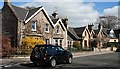
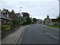
St Andrews Road, Lhanbryde
Until the Lhanbryde bypass was opened in 1995, the occupants of these Victorian villas in the village's main street, which was the main trunk road between Aberdeen and Inverness, suffered greatly from traffic noise and pollution. Now they enjoy peace and quiet close to the centre of the old village.
Image: © Anne Burgess
Taken: 5 Apr 2007
0.12 miles
9
Lhanbryde
Looking from St Andrews Road up the lane which links it to Walkers Crescent. Behind the older houses are the roofs of some of the vast tract of modern housing on the north side of the old village.
Image: © Anne Burgess
Taken: 5 Apr 2007
0.13 miles
10
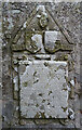
Innes Enclosure (3)
The Innes Enclosure is a Category A Listed building in the old kirkyard at Lhanbryde. This tablet, to the right of the effigy in Image], commemorates Maria Gordon, who died in 1647, wife of Sir Alexander Innes who completed Coxton Tower.
Image: © Anne Burgess
Taken: 6 Mar 2021
0.14 miles