IMAGES TAKEN NEAR TO
Fleurs Place, ELGIN, IV30 1ST
Introduction
This page details the photographs taken nearby to Fleurs Place, IV30 1ST by members of the Geograph project.
The Geograph project started in 2005 with the aim of publishing, organising and preserving representative images for every square kilometre of Great Britain, Ireland and the Isle of Man.

There are currently over 7.5m images from over14,400 individuals and you can help contribute to the project by visiting https://www.geograph.org.uk
Image Map (Loading...)


Getting Data...Please wait
Leaflet Map data © OpenStreetMap
Images are licensed for reuse under creativecommons.org/licenses/by-sa/2.0
Notes
- Clicking on the map will re-center to the selected point.
- The higher the marker number, the further away the image location is from the centre of the postcode.
Image Listing (11 Images Found)
Images are licensed for reuse under creativecommons.org/licenses/by-sa/2.0
Image
Details
Distance
2
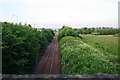
Mayne Rail
The view south from Mayne Farm Bridge.
Image: © Andrew Wood
Taken: 16 Jun 2009
0.14 miles
3
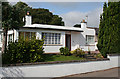
Art Deco House
This is the only house in the street that merits a mention in the Moray architectural guide, which says that although completed after the Second World War it "offers a pure 1930s aesthetic".
Image: © Anne Burgess
Taken: 23 Jul 2014
0.20 miles
4
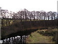
River Lossie bend
Mature deciduous woodland on the outside of a bend on the River Lossie. The view is from the A96 road bridge at Sheriffmills.
Image: © John MacDonald
Taken: 5 Mar 2007
0.20 miles
5
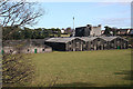
Glen Moray Distillery
The west side of the distillery buildings. The dark colour of the stonework is the result of staining by vapours given off during the distilling and maturation of the whisky. The West Brewery was built on this site in 1831, and in 1897 production shifted from beer to whisky. It produces a very fine Speyside malt. Tours of the distillery are available.
Image: © Anne Burgess
Taken: 1 Mar 2011
0.20 miles
6
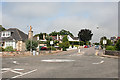
Wittet Drive
The Council is promoting a controversial and unpopular plan to turn Wittet Drive into a town bypass. Since they first mooted it the Scottish Government has announced a proper dual carriageway to link Aberdeen to Inverness, which would completely bypass the built-up area, so it is rather difficult to understand why the Council is so determined to go ahead with their plan.
Image: © Anne Burgess
Taken: 23 Jul 2014
0.21 miles
7
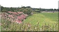
Palmer's Cross
Looking upriver from Mayne towards Palmer's Cross. This was so named because it was where pilgrims - palmers - crossed the river during their journeys. The holiday chalets in the grounds can be seen at far right.
Image: © Anne Burgess
Taken: 25 Aug 2006
0.21 miles
8

Dr Gray's Hospital
The foundation stone of Elgin's general hospital building was laid in 1815, on the day the news of the Battle of Waterloo reached the town. Sadly, since this photograph was taken, the elegant symmetry of the building has been destroyed by the addition of a prominent modern extension behind and to the left Image
Image: © Anne Burgess
Taken: Unknown
0.22 miles
9
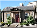
Gate Lodge, Dr Gray's Hospital
A neat little lodge guards the north entrance to the hospital grounds.
Image: © Anne Burgess
Taken: 14 Jul 2006
0.24 miles
10
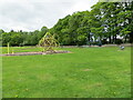
Recreational Play Area, Elgin
Looking north-westward.
Image: © Peter Wood
Taken: 13 May 2022
0.24 miles