IMAGES TAKEN NEAR TO
Hawthorn Court, ELGIN, IV30 1PR
Introduction
This page details the photographs taken nearby to Hawthorn Court, IV30 1PR by members of the Geograph project.
The Geograph project started in 2005 with the aim of publishing, organising and preserving representative images for every square kilometre of Great Britain, Ireland and the Isle of Man.

There are currently over 7.5m images from over14,400 individuals and you can help contribute to the project by visiting https://www.geograph.org.uk
Image Map
Images are licensed for reuse under creativecommons.org/licenses/by-sa/2.0
Notes
- Clicking on the map will re-center to the selected point.
- The higher the marker number, the further away the image location is from the centre of the postcode.
Image Listing (60 Images Found)
Images are licensed for reuse under creativecommons.org/licenses/by-sa/2.0
Image
Details
Distance
2
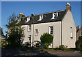
Rear Elevation
A traditional style house, formerly part of the electricity board offices and now belonging to a commercial company. Only in midsummer does the sun shine on this north elevation.
Image: © Anne Burgess
Taken: 13 Jul 2011
0.08 miles
4
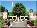
Ladyhill. Elgin
These pleasant gardens lie at the foot of the Ladyhill just outside the town centre. The column is a memorial to George, 5th Duke of Gordon and was erected in 1839.
Image: © Richard Slessor
Taken: 16 Sep 2006
0.11 miles
5
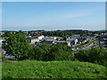
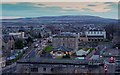
View from Ladyhill, Elgin
This view was taken from the remains of Elgin Castle. It shows the A96 Aberdeen to Inverness road running through the centre of Elgin. Tesco's car park can be seen on the left of the picture and the bus station is just visible on the far right.
Image: © Richard Slessor
Taken: 16 Sep 2006
0.11 miles
7
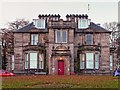
Maryhill House Elgin
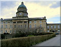
Maryhill House now the home to the occupational health service, is grade B listed, and dates from around 1817
Image: © valenta
Taken: 26 Nov 2017
0.13 miles
8
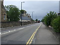
West Road (A96), Elgin
Heading west towards Forres.
Image: © JThomas
Taken: 19 Jul 2014
0.14 miles
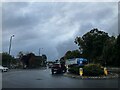
9
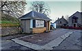
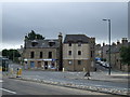
Avery Weighbridge and Office
Disused Avery weighbridge and office, the office now serving as a tourist information point, below Lady Hill
Image: © valenta
Taken: 26 Nov 2017
0.14 miles
10
South Elgin viewed from Lady Hill
View from Lady Hill, the A941 on the left with the tranismitter mast on the skyline of Brown Muir just visible.
Image: © valenta
Taken: 26 Nov 2017
0.14 miles