IMAGES TAKEN NEAR TO
LAIRG, IV27 4EF
Introduction
This page details the photographs taken nearby to IV27 4EF by members of the Geograph project.
The Geograph project started in 2005 with the aim of publishing, organising and preserving representative images for every square kilometre of Great Britain, Ireland and the Isle of Man.

There are currently over 7.5m images from over14,400 individuals and you can help contribute to the project by visiting https://www.geograph.org.uk
Image Map (Loading...)


Getting Data...Please wait
Leaflet Map data © OpenStreetMap
Images are licensed for reuse under creativecommons.org/licenses/by-sa/2.0
Notes
- Clicking on the map will re-center to the selected point.
- The higher the marker number, the further away the image location is from the centre of the postcode.
Image Listing (8 Images Found)
Images are licensed for reuse under creativecommons.org/licenses/by-sa/2.0
Image
Details
Distance

4
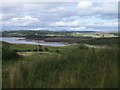
Southern Loch Shin
Southern extent of Loch Shin - the part without the dam
Image: © Graeme Smith
Taken: 29 Aug 2008
0.12 miles
6

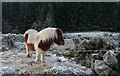
Tree and renovation project on the road to Sallachy
Image: © Peter Moore
Taken: 15 Dec 2015
0.24 miles
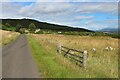
7
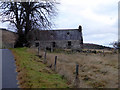
Ruined croft house beside the road to Sallachy
Has been replaced by a nearby modern building.
Image: © John Lucas
Taken: 10 Jan 2019
0.24 miles
8
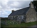
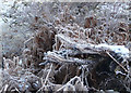
Abandoned Croft
Abandoned but not ruined croft
Image: © Graeme Smith
Taken: 29 Aug 2008
0.24 miles