IMAGES TAKEN NEAR TO
Daviot, INVERNESS, IV2 6XN
Introduction
This page details the photographs taken nearby to IV2 6XN by members of the Geograph project.
The Geograph project started in 2005 with the aim of publishing, organising and preserving representative images for every square kilometre of Great Britain, Ireland and the Isle of Man.

There are currently over 7.5m images from over14,400 individuals and you can help contribute to the project by visiting https://www.geograph.org.uk
Image Map (Loading...)


Getting Data...Please wait
Leaflet Map data © OpenStreetMap
Images are licensed for reuse under creativecommons.org/licenses/by-sa/2.0
Notes
- Clicking on the map will re-center to the selected point.
- The higher the marker number, the further away the image location is from the centre of the postcode.
Image Listing (8 Images Found)
Images are licensed for reuse under creativecommons.org/licenses/by-sa/2.0
Image
Details
Distance
1
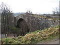
Bridge of Faillie
General Wade's military road south from Inverness crosses over this bridge. I expect the bridge was built as part of the road. Now a very minor road used by only local traffic.
Image: © David Greenhalgh
Taken: 21 Apr 2006
0.04 miles
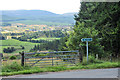
2
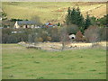
Faillie
Taken on Challenge 09. Small hamlet on the outskirts of Inverness.
Image: © peter goddard
Taken: 12 May 2009
0.04 miles
3
Bridge of Faillie
A stone arch bridge, over the River Nairn. The road is now a dead-end, just leading to a few houses.
This was the route of General Wade's Military Road, though it is unclear if this is the original bridge. The bridge is a Category B listed building. https://portal.historicenvironment.scot/designation/LB1683
Image: © Craig Wallace
Taken: 4 Nov 2020
0.08 miles
4
Bridge of Faillie
Viewed from the B851 road before it joins the A9 to the east.
Image: © Dave Fergusson
Taken: 2 Nov 2012
0.08 miles
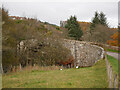
6
Over the Bridge of Faillie
A stone arch bridge, over the River Nairn. Now a narrow single track road, with grassy verges over the bridge.
This was the route of General Wade's Military Road, though it is unclear if this is the original bridge. The bridge is a Category B listed building. https://portal.historicenvironment.scot/designation/LB1683
Image: © Craig Wallace
Taken: 4 Nov 2020
0.09 miles
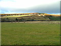
7
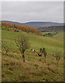
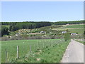
Fields, by Faillie
Rough grazing on the slopes of Strathnairn. A few cattle in the field.
Image: © Craig Wallace
Taken: 4 Nov 2020
0.22 miles
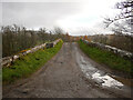
8
General Wade's Military Road
Public right of way from Inverness to Moy.
Image: © Steven Brown
Taken: 26 Aug 2012
0.24 miles