IMAGES TAKEN NEAR TO
Torness, INVERNESS, IV2 6TY
Introduction
This page details the photographs taken nearby to IV2 6TY by members of the Geograph project.
The Geograph project started in 2005 with the aim of publishing, organising and preserving representative images for every square kilometre of Great Britain, Ireland and the Isle of Man.

There are currently over 7.5m images from over14,400 individuals and you can help contribute to the project by visiting https://www.geograph.org.uk
Image Map
Images are licensed for reuse under creativecommons.org/licenses/by-sa/2.0
Notes
- Clicking on the map will re-center to the selected point.
- The higher the marker number, the further away the image location is from the centre of the postcode.
Image Listing (10 Images Found)
Images are licensed for reuse under creativecommons.org/licenses/by-sa/2.0
Image
Details
Distance
1
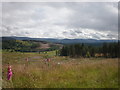
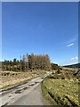
Cleared Forestry Behind Balnagarline
Most of the trees were gone except those near burn and Balnagarline, which can just be seen behind trees
Image: © Sarah McGuire
Taken: 17 Jul 2008
0.09 miles
4
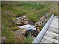
Crossing Burn from Carn an Dubh-ghlaic
The foot bridge was up the hill behind house. Most of the trees had been cut down.
Image: © Sarah McGuire
Taken: 17 Jul 2008
0.13 miles
5
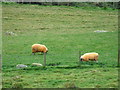
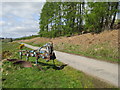
Sheep in field above river Farigaig
Apparently orange sheep in a field above the River Farigaig
Image: © Steven Brown
Taken: 23 Oct 2004
0.15 miles
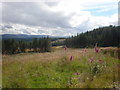
7
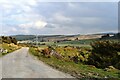
River Farigaig from Tom Fhionnlaidh
The River Farigaig flows through this broad strath on its way to where it joins Loch Ness at Inverfarigaig.
Image: © Robert Struthers
Taken: 11 Apr 2019
0.17 miles
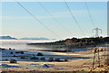
10
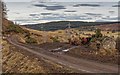
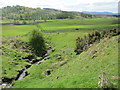
Cattle next to the unclassified road from Torness to Inverfarigaig
Cattle and sheep use the roadside from Balchraggan to the cattle grid South of Ballaggan as rough grazing, this and the extensive potholes and ruts make for an interesting ride whether on two or four wheels.
Image: © valenta
Taken: 17 Feb 2017
0.23 miles