IMAGES TAKEN NEAR TO
Averon Gardens, IV2 6HL
Introduction
This page details the photographs taken nearby to Averon Gardens, IV2 6HL by members of the Geograph project.
The Geograph project started in 2005 with the aim of publishing, organising and preserving representative images for every square kilometre of Great Britain, Ireland and the Isle of Man.

There are currently over 7.5m images from over14,400 individuals and you can help contribute to the project by visiting https://www.geograph.org.uk
Image Map
Images are licensed for reuse under creativecommons.org/licenses/by-sa/2.0
Notes
- Clicking on the map will re-center to the selected point.
- The higher the marker number, the further away the image location is from the centre of the postcode.
Image Listing (44 Images Found)
Images are licensed for reuse under creativecommons.org/licenses/by-sa/2.0
Image
Details
Distance
2
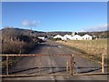
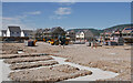
Housing development, Ness Side
Part of a new housing development, under construction between Dores Road and the River Ness. This street is off Peffery Avenue.
A rather dreich day, with rain and snow blowing in.
Image: © Craig Wallace
Taken: 9 Feb 2022
0.08 miles
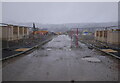
3
Derelict Sawmill
This carbuncle, once an old sawmill is a scene that greets visitors to Inverness on the new A8082 West Link Road just after crossing the River Ness at the Mill Lade Roundabout.
Image: © valenta
Taken: 1 Jan 2018
0.08 miles
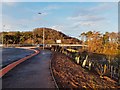
4
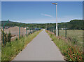
Path, by Ness Side
A useful route for walking and cycling between Dores Road and the Holm Mills Bridge.
Image: © Craig Wallace
Taken: 1 Jul 2021
0.10 miles
5
Housing under construction, Ness Side
The Tulloch Homes Ness Side housing development, between Dores Road and the River Ness. Part of it is being built on the site of an old sawmill and concrete plant.
Image: © Craig Wallace
Taken: 1 Jul 2021
0.11 miles
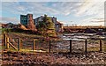
6
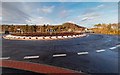
Mill Lade Roundabout Inverness
On the new Inverness West Link A8082 road, the new Holm Mills Bridge over the River Ness off to the right
Image: © valenta
Taken: 1 Jan 2018
0.12 miles
7
Mill Lade Roundabout Inverness
Looking to the new A8082 Holm Mills Bridge over the River Ness, the tree-lined hill at Torvean in the background
Image: © valenta
Taken: 1 Jan 2018
0.13 miles
8
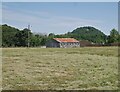
Old shed, by Holm Mills
Looking across a grassy field, towards a wooden shed with a tin roof. The hill of Tomnahurich cemetery behind.
Image: © Craig Wallace
Taken: 1 Jul 2021
0.14 miles
9
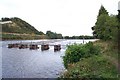
River Ness near Ness-side
The picture shows a sluice (foreground) and a weir. In the middle left of the picture the straight edge a few metres above river level is the bank of the Caledonian Canal (not itself visible) which then veers away to the left. The distant trees just to right of centre show where the river divides around Whin Island.
Image: © David Greenhalgh
Taken: 3 Sep 2003
0.15 miles
10
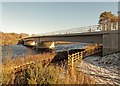
Holm Mills Bridge
Recently completed bridge over the River Ness, forming part of the new Inverness West Link Road
Image: © valenta
Taken: 31 Jan 2019
0.15 miles