IMAGES TAKEN NEAR TO
Willow Avenue, INVERNESS, IV2 6BT
Introduction
This page details the photographs taken nearby to Willow Avenue, IV2 6BT by members of the Geograph project.
The Geograph project started in 2005 with the aim of publishing, organising and preserving representative images for every square kilometre of Great Britain, Ireland and the Isle of Man.

There are currently over 7.5m images from over14,400 individuals and you can help contribute to the project by visiting https://www.geograph.org.uk
Image Map (Loading...)


Getting Data...Please wait
Leaflet Map data © OpenStreetMap
Images are licensed for reuse under creativecommons.org/licenses/by-sa/2.0
Notes
- Clicking on the map will re-center to the selected point.
- The higher the marker number, the further away the image location is from the centre of the postcode.
Image Listing (9 Images Found)
Images are licensed for reuse under creativecommons.org/licenses/by-sa/2.0
Image
Details
Distance
1

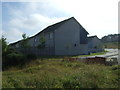
Land under development at Slackbuie, Inverness
The City of Inverness is increasing its housing stock in this private development.
Image: © Douglas Nelson
Taken: 29 May 2017
0.08 miles
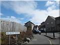
2
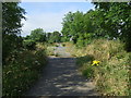
Road in the new development at Upper Slackbuie
Image: © Steven Brown
Taken: 5 Oct 2010
0.09 miles
3
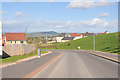
Duke's View, Inverness
Recently built housing on the outskirts of Inverness
Image: © Alpin Stewart
Taken: 6 Apr 2016
0.11 miles
4

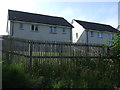
Affordable housing development, Lower Slackbuie
The Highland Council makes it a planning requirement that all new housing developments in the private sector of 10 or more homes must contain 25% affordable homes.
Image: © E Sandland
Taken: 24 Jun 2009
0.16 miles
5
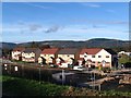
Morning Field Road, Culduthel, Inverness
Housing development under construction in 2006, Culduthel.
Image: © E Sandland
Taken: 3 Nov 2006
0.20 miles
6

Earthworks amid housing development
A large housing development is currently underway on the hillside of Upper Slackbuie. The new trench photographed here is part of a flood protection scheme.
Image: © Richard Dorrell
Taken: 29 Jan 2013
0.20 miles