IMAGES TAKEN NEAR TO
Bishopfield Road, DORNOCH, IV25 3LJ
Introduction
This page details the photographs taken nearby to Bishopfield Road, IV25 3LJ by members of the Geograph project.
The Geograph project started in 2005 with the aim of publishing, organising and preserving representative images for every square kilometre of Great Britain, Ireland and the Isle of Man.

There are currently over 7.5m images from over14,400 individuals and you can help contribute to the project by visiting https://www.geograph.org.uk
Image Map (Loading...)


Getting Data...Please wait
Leaflet Map data © OpenStreetMap
Images are licensed for reuse under creativecommons.org/licenses/by-sa/2.0
Notes
- Clicking on the map will re-center to the selected point.
- The higher the marker number, the further away the image location is from the centre of the postcode.
Image Listing (193 Images Found)
Images are licensed for reuse under creativecommons.org/licenses/by-sa/2.0
Image
Details
Distance
1
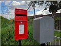
Royal Mail Post Box, Bishopfield
A cast iron pedestal-mounted lamp box. All of Dornoch's post boxes are in good condition at the moment.
Image: © David Bremner
Taken: 13 Jun 2021
0.07 miles
2
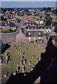
Graveyard from tower of Dornoch Cathedral, Sutherland
Looking due east from the Tower of Dornoch Cathedral we have a shadow of the tower on the right of the image, with the houses of the town and in the distance the North Sea.
Image: © Christine Matthews
Taken: Unknown
0.09 miles

4
When is a well not a well
St Michael's well. The real well is closer to town. This stone was put here in 1832 by George Gunn, factor to the Duke of Sutherland. A new law declared that only men living within 7 miles of the burgh boundary could vote in the country's elections. Dornoch's northern boundary was set at St Michael's well. Unfortunately for George his home was just outside the 7 mile limit, he could have moved house to save his vote, but instead he moved the boundary.
Image: © Ralph Greig
Taken: 12 Aug 2023
0.09 miles
5
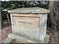
St Michaels Well, or is it?
St Michael's well. The real well is closer to town. This stone was put here in 1832 by George Gunn, factor to the Duke of Sutherland. A new law declared that only men living within 7 miles of the burgh boundary could vote in the country's elections. Dornoch's northern boundary was set at St Michael's well. Unfortunately for George his home was just outside the 7 mile limit, he could have moved house to save his vote, but instead he moved the boundary.
Image: © Ralph Greig
Taken: 12 Aug 2023
0.09 miles
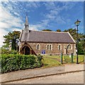
6
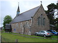
St Finnbarr's Episcopal Church, Dornoch
St Finnbarr's is also shared by the Roman Catholic Church in Dornoch.
Image: © Bill Henderson
Taken: 15 Jun 2008
0.10 miles
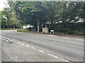
7
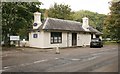
Highland Chiropractic Clinic, Station Road, Dornoch
The building is the former Dornoch Station, the terminus of the Dornoch Light Railway, which ran north to The Mound, where it joined the main line between Inverness and Wick/Thurso. The station opened on 2 June 1902 and closed to regular passenger traffic on 13 June 1960.
Image: © Richard Sutcliffe
Taken: 25 Sep 2018
0.10 miles
8
Dornoch railway station (site), Highland
Opened in 1902 on the Highland Railway's branch line from The Mound, this station closed in 1960.
View north east from the former buffers towards Embo and The Mound. The building and platform were still intact 55 years after closure - a remarkable survivor.
Image: © Nigel Thompson
Taken: 28 Mar 2015
0.10 miles
10
Saint Finnbarr's Episcopal Church
On School Hill Dornoch
Image: © valenta
Taken: 14 May 2018
0.12 miles