IMAGES TAKEN NEAR TO
Dores Road, INVERNESS, IV2 4RW
Introduction
This page details the photographs taken nearby to Dores Road, IV2 4RW by members of the Geograph project.
The Geograph project started in 2005 with the aim of publishing, organising and preserving representative images for every square kilometre of Great Britain, Ireland and the Isle of Man.

There are currently over 7.5m images from over14,400 individuals and you can help contribute to the project by visiting https://www.geograph.org.uk
Image Map (Loading...)


Getting Data...Please wait
Leaflet Map data © OpenStreetMap
Images are licensed for reuse under creativecommons.org/licenses/by-sa/2.0
Notes
- Clicking on the map will re-center to the selected point.
- The higher the marker number, the further away the image location is from the centre of the postcode.
Image Listing (16 Images Found)
Images are licensed for reuse under creativecommons.org/licenses/by-sa/2.0
Image
Details
Distance
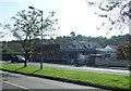
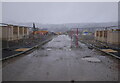
2
Dores Road (B862)
Heading north east towards Inverness.
Image: © JThomas
Taken: 22 Jul 2014
0.08 miles
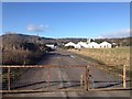
4
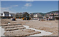
Housing under construction, Ness Side
The Tulloch Homes Ness Side housing development, between Dores Road and the River Ness. Part of it is being built on the site of an old sawmill and concrete plant.
Image: © Craig Wallace
Taken: 1 Jul 2021
0.14 miles
5
Housing development, Ness Side
Part of a new housing development, under construction between Dores Road and the River Ness. This street is off Peffery Avenue.
A rather dreich day, with rain and snow blowing in.
Image: © Craig Wallace
Taken: 9 Feb 2022
0.15 miles
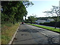
6
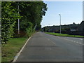
Dores Road (B862)
Heading north east towards Inverness.
Image: © JThomas
Taken: 22 Jul 2014
0.16 miles
8
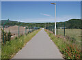
Path, by Ness Side
A useful route for walking and cycling between Dores Road and the Holm Mills Bridge.
Image: © Craig Wallace
Taken: 1 Jul 2021
0.18 miles
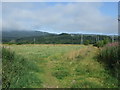
9
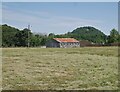
Old shed, by Holm Mills
Looking across a grassy field, towards a wooden shed with a tin roof. The hill of Tomnahurich cemetery behind.
Image: © Craig Wallace
Taken: 1 Jul 2021
0.20 miles
10
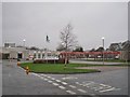
Holm Primary School
Local authority primary school, with currently 207 pupils in P1-7, and a further 35 children in the Nursery.
Image: © Richard Dorrell
Taken: 15 Dec 2013
0.22 miles