IMAGES TAKEN NEAR TO
Sunnybank Avenue, INVERNESS, IV2 4HD
Introduction
This page details the photographs taken nearby to Sunnybank Avenue, IV2 4HD by members of the Geograph project.
The Geograph project started in 2005 with the aim of publishing, organising and preserving representative images for every square kilometre of Great Britain, Ireland and the Isle of Man.

There are currently over 7.5m images from over14,400 individuals and you can help contribute to the project by visiting https://www.geograph.org.uk
Image Map
Images are licensed for reuse under creativecommons.org/licenses/by-sa/2.0
Notes
- Clicking on the map will re-center to the selected point.
- The higher the marker number, the further away the image location is from the centre of the postcode.
Image Listing (24 Images Found)
Images are licensed for reuse under creativecommons.org/licenses/by-sa/2.0
Image
Details
Distance
1
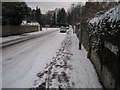
Sunnybank Road, Inverness
Viewed from its junction with Muirfield Road. In weather conditions such as seen here, the road name made me smile. The snowfall had been the previous evening.
Image: © Richard Dorrell
Taken: 14 Dec 2012
0.05 miles
2

Entrance to Hedgefield House
This entrance is off Culduthel Road. The blue and white sign reads: "Site Acquired for Future Development". This development will be the building of some 40 new homes and the restoration of Hedgefield House (built 1821) which will be converted for use as offices. (House: Image] ). The trees are subject to preservation orders, and will be retained. A cast metal plaque on the gatepost (right of centre) shows the most recent past use of Hedgefield House as boarding accommodation for Inverness Academy. (Detail of plaque: Image]).
Image: © Richard Dorrell
Taken: 17 Apr 2013
0.07 miles
3

Gatepost plaque, Hedgefield House
This plaque is on a gatepost at the entrance to Hedgefield House, off Culduthel Road. The house (built 1821) is currently boarded up awaiting restoration and redevelopment into offices.
Wider view of entrance: Image] .
House: Image] .
Image: © Richard Dorrell
Taken: 17 Apr 2013
0.07 miles
4
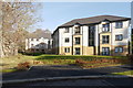
Hedgefield Apartments
Modern apartments within the grounds of Hedgefield House, off Culduthel Road. They were built by Tulloch Homes, and completed last year.
Image: © Craig Wallace
Taken: 3 Feb 2017
0.07 miles
5
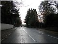
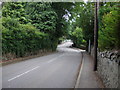
Culduthel Road, Inverness
Approaching the junction of Drummond Road and Muirfield Road.
Image: © Douglas Nelson
Taken: 26 Nov 2017
0.07 miles
6
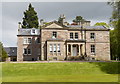
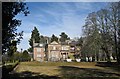
Hedgefield House
Hedgefield House is a Category B listed mansion, on Culduthel Road in Inverness. It was originally built in 1821, with extensions in 1846. For many years it was a hostel for pupils at Inverness Royal Academy. More recently, it was used by Inverness College as a management training centre.
Hedgefield House was bought by Tulloch Homes in 2007, and it has now been developed into luxury apartments. Tulloch have also built several new apartment blocks within the grounds of the house.
See for a similar view in 2013 Image
Image: © Craig Wallace
Taken: 22 May 2016
0.11 miles
7
Hedgefield House, Culduthel Road
The mansion has been used in the past as an hotel, a hospital, and most recently as a boarding hostel for female pupils of Inverness Royal Academy. It was built in 1821 for Bishop Robert Eden, the Bishop of Moray, and has been recently been sold to Tulloch Homes for £2.2 million. Plans are now in place to restore the mansion, which is Category B listed, and convert it to office accommodation, while some 40 new homes will be built in its grounds. Almost all the trees in the grounds are subject to tree preservation orders, and will be retained. Entrance to site: Image
Image: © Richard Dorrell
Taken: 17 Apr 2013
0.11 miles
8

Bungalows in Heatherley Crescent
The crescent is not actually a crescent, but is two adjoining cul-de-sacs. The crescent is a turning off Culduthel Road.
Image: © Richard Dorrell
Taken: 17 Apr 2013
0.11 miles
10
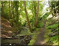
Aultnaskiach Dell
Aultnaskiach Dell is a thin strip of woodland, alongside the Allt na Sgitheach (Aultnaskiach Burn). Much of it is a fairly steep gorge, with a variety of tall trees. It can be accessed by a path off Drummond Road.
For the last few years, Aultnaskiach Dell has been managed by a community group, who are aiming to take ownership of it. Work has been going on to plant native trees, and remove invasive species. http://aultnaskiachdell.blogspot.co.uk/
Image: © Craig Wallace
Taken: 22 May 2016
0.14 miles