IMAGES TAKEN NEAR TO
ARDGAY, IV24 3BW
Introduction
This page details the photographs taken nearby to IV24 3BW by members of the Geograph project.
The Geograph project started in 2005 with the aim of publishing, organising and preserving representative images for every square kilometre of Great Britain, Ireland and the Isle of Man.

There are currently over 7.5m images from over14,400 individuals and you can help contribute to the project by visiting https://www.geograph.org.uk
Image Map
Images are licensed for reuse under creativecommons.org/licenses/by-sa/2.0
Notes
- Clicking on the map will re-center to the selected point.
- The higher the marker number, the further away the image location is from the centre of the postcode.
Image Listing (16 Images Found)
Images are licensed for reuse under creativecommons.org/licenses/by-sa/2.0
Image
Details
Distance
1
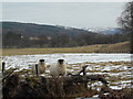
Curious sheep, Gruinards, Strathcarron
Image: © sylvia duckworth
Taken: 10 Mar 2010
0.10 miles

4
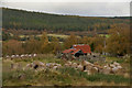
Disused Barn at Wester Dounie, Strath Carron, Ross-shire
A quiet autumnal rural scene from north eastern Scotland. Some of the hay bales had been lying around for quite some time as they had fresh grass starting to grow out of them.
Image: © Andrew Tryon
Taken: 19 Oct 2019
0.14 miles
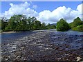
5
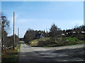
Wester Dounie
I always prefer to travel back down Strath Carron on the south side, especially whilst cycling.
Image: © Peter Moore
Taken: 26 Mar 2012
0.15 miles

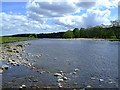
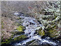
9
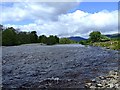
The River Carron
At Culeave looking up river.
Image: © Donald H Bain
Taken: 25 May 2007
0.19 miles
10
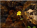
Marsh Marigold
Growing in the edge of the River Carron.
Image: © Donald H Bain
Taken: 25 May 2007
0.19 miles