IMAGES TAKEN NEAR TO
East Mackenzie Park, INVERNESS, IV2 3SS
Introduction
This page details the photographs taken nearby to East Mackenzie Park, IV2 3SS by members of the Geograph project.
The Geograph project started in 2005 with the aim of publishing, organising and preserving representative images for every square kilometre of Great Britain, Ireland and the Isle of Man.

There are currently over 7.5m images from over14,400 individuals and you can help contribute to the project by visiting https://www.geograph.org.uk
Image Map
Images are licensed for reuse under creativecommons.org/licenses/by-sa/2.0
Notes
- Clicking on the map will re-center to the selected point.
- The higher the marker number, the further away the image location is from the centre of the postcode.
Image Listing (11 Images Found)
Images are licensed for reuse under creativecommons.org/licenses/by-sa/2.0
Image
Details
Distance
1
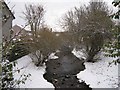
Mill Burn
A wintry look upstream from a bridge in Mason Road, Hilton.
Image: © Richard Dorrell
Taken: 14 Dec 2012
0.10 miles
2
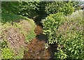
Mill Burn between Hilton and Draikies
Image: © Douglas Nelson
Taken: 3 Jun 2021
0.12 miles
3
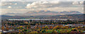
View over Inverness City from the new Inshes Park
A panoramic view shot from the new southern Inshes Park from this location Image] over Inverness. The established northern Inshes Park is just in view in the bottom of this image, with the Beauly Firth in the centre of the image. What this image demonstrates though, is how once one gains some height how Ben Wyvis over 21 miles away completely dominates the Inverness skyline to the north.
Image: © valenta
Taken: 8 Nov 2018
0.16 miles
4
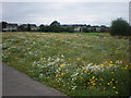
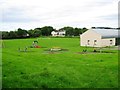
Field of Wild Flowers In Inverness
The Council planted the roundabouts on B8082 with wild flowers. This field adjoins the B8082 road and a school playing field. The path links the houses in image with the retail park.
Image: © Sarah McGuire
Taken: 20 Aug 2008
0.18 miles
6
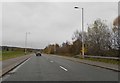
The B8082
Passes through the southern suburbs of Inverness
Image: © Douglas Nelson
Taken: 27 Nov 2017
0.19 miles
7
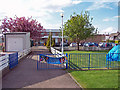
Drakies Primary School
Viewed from Drumossie Avenue, Inverness.
Some pupils have recently transferred from here to the nearby Inshes Primary School which opened in August 2007.
Image: © Richard Dorrell
Taken: 29 Apr 2009
0.19 miles
8
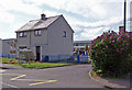
Caretakers House, Drakies Primary School
The house stands at the entrance to Drakies Primary School in Drumossie Avenue.
Image: © Richard Dorrell
Taken: 29 Apr 2009
0.20 miles
9
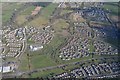
Aerial View of Inshes District Park and Inshes, Inverness
Aerial view facing southeast over Inshes District Park, city of Inverness, Great Britain. The main road running from left to right is the Inverness Southern distributor road.
Image: © Andrew Tryon
Taken: 17 Apr 2017
0.22 miles
10
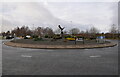
Dellfield Roundabout, Inshes
A roundabout on Sir Walter Scott Drive (A8082). It is a junction for Inshes Retail Park.
It includes a metal eagle sculpture in the middle, topped with a Santa hat.
Image: © Craig Wallace
Taken: 30 Dec 2021
0.22 miles