IMAGES TAKEN NEAR TO
Harris Road, INVERNESS, IV2 3PF
Introduction
This page details the photographs taken nearby to Harris Road, IV2 3PF by members of the Geograph project.
The Geograph project started in 2005 with the aim of publishing, organising and preserving representative images for every square kilometre of Great Britain, Ireland and the Isle of Man.

There are currently over 7.5m images from over14,400 individuals and you can help contribute to the project by visiting https://www.geograph.org.uk
Image Map
Images are licensed for reuse under creativecommons.org/licenses/by-sa/2.0
Notes
- Clicking on the map will re-center to the selected point.
- The higher the marker number, the further away the image location is from the centre of the postcode.
Image Listing (5 Images Found)
Images are licensed for reuse under creativecommons.org/licenses/by-sa/2.0
Image
Details
Distance
1
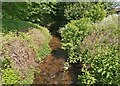
Mill Burn between Hilton and Draikies
Image: © Douglas Nelson
Taken: 3 Jun 2021
0.06 miles
3
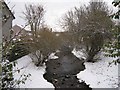
Mill Burn
A wintry look upstream from a bridge in Mason Road, Hilton.
Image: © Richard Dorrell
Taken: 14 Dec 2012
0.15 miles
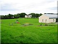
4
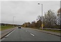
The B8082
Passes through the southern suburbs of Inverness
Image: © Douglas Nelson
Taken: 27 Nov 2017
0.23 miles
5
View over Inverness City from the new Inshes Park
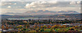
A panoramic view shot from the new southern Inshes Park from this location Image] over Inverness. The established northern Inshes Park is just in view in the bottom of this image, with the Beauly Firth in the centre of the image. What this image demonstrates though, is how once one gains some height how Ben Wyvis over 21 miles away completely dominates the Inverness skyline to the north.
Image: © valenta
Taken: 8 Nov 2018
0.25 miles