IMAGES TAKEN NEAR TO
Miller Gardens, INVERNESS, IV2 3DT
Introduction
This page details the photographs taken nearby to Miller Gardens, IV2 3DT by members of the Geograph project.
The Geograph project started in 2005 with the aim of publishing, organising and preserving representative images for every square kilometre of Great Britain, Ireland and the Isle of Man.

There are currently over 7.5m images from over14,400 individuals and you can help contribute to the project by visiting https://www.geograph.org.uk
Image Map
Images are licensed for reuse under creativecommons.org/licenses/by-sa/2.0
Notes
- Clicking on the map will re-center to the selected point.
- The higher the marker number, the further away the image location is from the centre of the postcode.
Image Listing (7 Images Found)
Images are licensed for reuse under creativecommons.org/licenses/by-sa/2.0
Image
Details
Distance

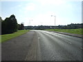
2
Green Fields between New Housing in Inverness
The local council policy is that there will be as much land left "Green" as there is built on. The building on the left is the new Inshes Primary School. The road is the B8082.
Image: © Sarah McGuire
Taken: 20 Aug 2008
0.17 miles
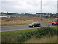
3
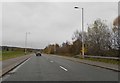
The B8082
Passes through the southern suburbs of Inverness
Image: © Douglas Nelson
Taken: 27 Nov 2017
0.18 miles

5
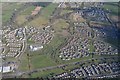
Aerial View of Inshes District Park and Inshes, Inverness
Aerial view facing southeast over Inshes District Park, city of Inverness, Great Britain. The main road running from left to right is the Inverness Southern distributor road.
Image: © Andrew Tryon
Taken: 17 Apr 2017
0.19 miles
6
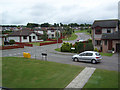
View from Miller Street towards Stevenson Road
Image: © Scott Macpherson
Taken: 13 Aug 2006
0.21 miles