IMAGES TAKEN NEAR TO
Craig Avenue, TAIN, IV19 1JP
Introduction
This page details the photographs taken nearby to Craig Avenue, IV19 1JP by members of the Geograph project.
The Geograph project started in 2005 with the aim of publishing, organising and preserving representative images for every square kilometre of Great Britain, Ireland and the Isle of Man.

There are currently over 7.5m images from over14,400 individuals and you can help contribute to the project by visiting https://www.geograph.org.uk
Image Map (Loading...)


Getting Data...Please wait
Leaflet Map data © OpenStreetMap
Images are licensed for reuse under creativecommons.org/licenses/by-sa/2.0
Notes
- Clicking on the map will re-center to the selected point.
- The higher the marker number, the further away the image location is from the centre of the postcode.
Image Listing (19 Images Found)
Images are licensed for reuse under creativecommons.org/licenses/by-sa/2.0
Image
Details
Distance
2
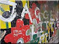
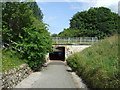
Underpass Artwork
Underpass beneath the A9.
Image: © David Bremner
Taken: 7 Sep 2022
0.07 miles
3
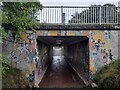
A9 Underpass at Tain
An underpass beneath the A9. The John o'Groats Trail makes use of it.
Image: © David Bremner
Taken: 7 Sep 2022
0.07 miles
5
Underpass beneath the A9
Cycle track towards Tain.
Image: © JThomas
Taken: 21 Jul 2014
0.08 miles
6
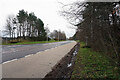
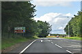
The A9 Tain Bypass
Can be a something of a problem to cross here on foot, despite the fact that the speed limit has been reduced to 50mph!
Image: © John Lucas
Taken: 6 Apr 2022
0.10 miles
9
Beside the A9 Tain Bypass
With its narrow streets, Tain must have been a nightmare to drive through before the bypass was opened.
Image: © John Lucas
Taken: 6 Apr 2022
0.12 miles