IMAGES TAKEN NEAR TO
Mansfield Estate, TAIN, IV19 1JJ
Introduction
This page details the photographs taken nearby to Mansfield Estate, IV19 1JJ by members of the Geograph project.
The Geograph project started in 2005 with the aim of publishing, organising and preserving representative images for every square kilometre of Great Britain, Ireland and the Isle of Man.

There are currently over 7.5m images from over14,400 individuals and you can help contribute to the project by visiting https://www.geograph.org.uk
Image Map (Loading...)


Getting Data...Please wait
Leaflet Map data © OpenStreetMap
Images are licensed for reuse under creativecommons.org/licenses/by-sa/2.0
Notes
- Clicking on the map will re-center to the selected point.
- The higher the marker number, the further away the image location is from the centre of the postcode.
Image Listing (23 Images Found)
Images are licensed for reuse under creativecommons.org/licenses/by-sa/2.0
Image
Details
Distance
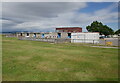
1
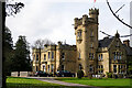
Mansfield Castle Hotel, Tain
Dating from the 1870s, the hotel stands beside the Scotsburn Road and is about a mile from the town centre.
Image: © John Lucas
Taken: 6 Apr 2022
0.08 miles
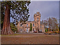
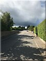
4
Scotsburn Road in Tain
Outside the Police Acadamy Buildings, this shows Scotsburn Road gradually descending into the centre of the Royal Burgh of Tain.
Image: © Chris Heaton
Taken: 13 May 2018
0.10 miles
7

Underpass Artwork
Underpass beneath the A9.
Image: © David Bremner
Taken: 7 Sep 2022
0.17 miles
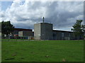
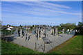
8

New Houses in Tain
These modern houses lie close to the traditional buildings in Scotsburn Road.
Image: © Mary and Angus Hogg
Taken: 25 Feb 2014
0.17 miles
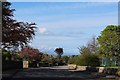
10
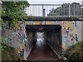
A9 Underpass at Tain
An underpass beneath the A9. The John o'Groats Trail makes use of it.
Image: © David Bremner
Taken: 7 Sep 2022
0.17 miles