IMAGES TAKEN NEAR TO
Knockbreck Gardens, TAIN, IV19 1GZ
Introduction
This page details the photographs taken nearby to Knockbreck Gardens, IV19 1GZ by members of the Geograph project.
The Geograph project started in 2005 with the aim of publishing, organising and preserving representative images for every square kilometre of Great Britain, Ireland and the Isle of Man.

There are currently over 7.5m images from over14,400 individuals and you can help contribute to the project by visiting https://www.geograph.org.uk
Image Map
Images are licensed for reuse under creativecommons.org/licenses/by-sa/2.0
Notes
- Clicking on the map will re-center to the selected point.
- The higher the marker number, the further away the image location is from the centre of the postcode.
Image Listing (8 Images Found)
Images are licensed for reuse under creativecommons.org/licenses/by-sa/2.0
Image
Details
Distance
1
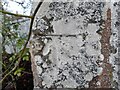
O.S Benchmark: Tain, Knockbreck Gatepost
Image: © David Bremner
Taken: 12 Dec 2021
0.13 miles
3
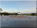
Roundabout at Knockbreck
Most probably put in when the Asda supermarket was built.
Image: © David Bremner
Taken: 12 Dec 2021
0.18 miles
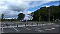
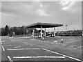
4

Advertising at Tain Asda
Two of these boards caught my eye which I suppose is partly the point!
Image: © David Bremner
Taken: 12 Dec 2021
0.21 miles
6
Former Tollhouse by the A9, south east of Tain
Toll House by the East side of the A9 on cut-off section, in parish of Tain (Highland District), Knockbreck Toll House.
Surveyed
Milestone Society National ID: HI.TAI
Image: © Milestone Society
Taken: Unknown
0.24 miles
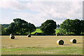
8
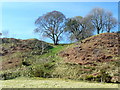
Raised beach near Tain
Approaching the raised beach on which the town of Tain sits.
Image: © sylvia duckworth
Taken: 5 Apr 2009
0.24 miles