IMAGES TAKEN NEAR TO
Craigton Road, INVERNESS, IV1 3YE
Introduction
This page details the photographs taken nearby to Craigton Road, IV1 3YE by members of the Geograph project.
The Geograph project started in 2005 with the aim of publishing, organising and preserving representative images for every square kilometre of Great Britain, Ireland and the Isle of Man.

There are currently over 7.5m images from over14,400 individuals and you can help contribute to the project by visiting https://www.geograph.org.uk
Image Map
Images are licensed for reuse under creativecommons.org/licenses/by-sa/2.0
Notes
- Clicking on the map will re-center to the selected point.
- The higher the marker number, the further away the image location is from the centre of the postcode.
Image Listing (97 Images Found)
Images are licensed for reuse under creativecommons.org/licenses/by-sa/2.0
Image
Details
Distance
1
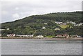
A9, The Black Isle
Despite its name, the Black Isle (Scottish Gaelic: an t-Eilean Dubh) is not an island. It is a peninsula within Ross and Cromarty, in the Scottish Highlands surrounded on three sides by water; the Cromarty Firth to the north, the Beauly Firth to the south, and the Moray Firth to the east.
Image: © David Dixon
Taken: 6 Apr 2017
0.01 miles
2
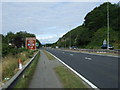
National Cycle Route 1
Heading west onto the Black Isle.
Beside the A9.
Image: © JThomas
Taken: 21 Jul 2014
0.01 miles
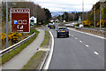
4
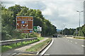
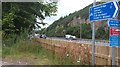
Welcome to The Black Isle and Ross & Cromarty, A9
Image: © N Chadwick
Taken: 15 Aug 2021
0.02 miles
5
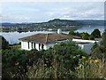
House above the Beauly Firth
Off National Cycle Route 1.
Image: © JThomas
Taken: 21 Jul 2014
0.02 miles
6
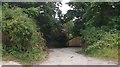
Path to North Kessock
A path down from the A9/Kessock Bridge via Old Craigton Road.
Image: © Richard Webb
Taken: 4 Aug 2015
0.03 miles
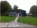
7
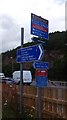
Signs, North Kessock
At the northern end of the bridge. Although I knew that the Cromarty Ferry was down, it was still deeply annoying - an extreme case of the current national obsession with closing roads.
Image: © Richard Webb
Taken: 4 Aug 2015
0.03 miles
8
A9, North Kessock
Approaches to the bridge and a signpost for the path over the Kessock Bridge.
Image: © Richard Webb
Taken: 4 Aug 2015
0.05 miles
9
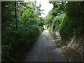
Old Craigton Road
Dropping down into North Kessock on National Cycle Route 1.
Image: © JThomas
Taken: 21 Jul 2014
0.07 miles