IMAGES TAKEN NEAR TO
Cromwell Road, INVERNESS, IV1 1SX
Introduction
This page details the photographs taken nearby to Cromwell Road, IV1 1SX by members of the Geograph project.
The Geograph project started in 2005 with the aim of publishing, organising and preserving representative images for every square kilometre of Great Britain, Ireland and the Isle of Man.

There are currently over 7.5m images from over14,400 individuals and you can help contribute to the project by visiting https://www.geograph.org.uk
Image Map (Loading...)


Getting Data...Please wait
Leaflet Map data © OpenStreetMap
Images are licensed for reuse under creativecommons.org/licenses/by-sa/2.0
Notes
- Clicking on the map will re-center to the selected point.
- The higher the marker number, the further away the image location is from the centre of the postcode.
Image Listing (79 Images Found)
Images are licensed for reuse under creativecommons.org/licenses/by-sa/2.0
Image
Details
Distance
1
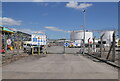
Oil terminal, Cromwell Road
Caledonian Oil Inverness Terminal, off Cromwell Road in the Longman industrial estate. This is the main entrance to the site.
Image: © Craig Wallace
Taken: 12 Jul 2022
0.03 miles
3
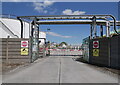
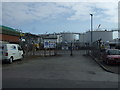
Oil terminal, Cromwell Road
Caledonian Oil Inverness Terminal, off Cromwell Road in the Longman industrial estate. This is an exit to the site, with pipes crossing above the road.
Image: © Craig Wallace
Taken: 12 Jul 2022
0.06 miles
4
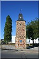
Harbour Clock Tower
The prominent Clock Tower on Cromwell Road and the site of a Cromwellian fort.
Image: © Andrew Wood
Taken: 27 Jul 2011
0.06 miles
5
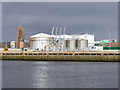
Inverness Oil Storage Terminal
Caledonian Oil storage depot on the bank of the River Ness at Inverness.
Image: © David Dixon
Taken: 4 Apr 2017
0.07 miles
6
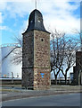
The Clock Tower
Located in the Longman part of Inverness, this tower and some fragemnts of walls are all that's left of the Cromwellian Citadel that occupied this site. The Citadel was founded in 1652 and was demolished 9 years later when the monarchy had been restored. The Clock Tower was restored in 2010.
Image: © Mary and Angus Hogg
Taken: 24 Feb 2014
0.07 miles
7
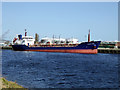
The Mersey Fisher
Berthed by the River Ness dockside. Despite its name the vessel is a chemical carrier registered in Gibraltar. It appears to spend most of its time running in the North Sea between Immingham and Inverness.
Image: © John Lucas
Taken: 12 Apr 2018
0.07 miles
8
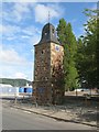
Cromwell's Tower, Cromwell Road, Inverness
This clock tower was formerly thought to be all that remains of Cromwell's fort (completed in 1658) in Inverness. The near square-plan red sandstone clock tower is now believed to date from the late 18th century. It is a Category B listed building. https://www.britishlistedbuildings.co.uk/200379726-inverness-cromwell-road-clock-tower-inverness#.WawHhjGWw5s
Image: © G Laird
Taken: 1 Sep 2017
0.07 miles
9
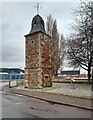
Cromwell's Tower
An historic feature within an industrial landscape.
Image: © David Bremner
Taken: 29 Jan 2023
0.08 miles
10
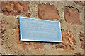
Plaque on the remains of Cromwell's Citadel
A simple plaque giving basic information about Cromwell's Citadel
Image: © Steven Brown
Taken: 9 Sep 2008
0.08 miles