IMAGES TAKEN NEAR TO
Denoon Place, CROMARTY, IV11 8YU
Introduction
This page details the photographs taken nearby to Denoon Place, IV11 8YU by members of the Geograph project.
The Geograph project started in 2005 with the aim of publishing, organising and preserving representative images for every square kilometre of Great Britain, Ireland and the Isle of Man.

There are currently over 7.5m images from over14,400 individuals and you can help contribute to the project by visiting https://www.geograph.org.uk
Image Map
Images are licensed for reuse under creativecommons.org/licenses/by-sa/2.0
Notes
- Clicking on the map will re-center to the selected point.
- The higher the marker number, the further away the image location is from the centre of the postcode.
Image Listing (512 Images Found)
Images are licensed for reuse under creativecommons.org/licenses/by-sa/2.0
Image
Details
Distance
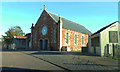
1
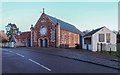
Victoria Hall High Street Cromarty
A category C listed building from 1887, the Victoria Hall was built as a drill hall by Andrew Maitland and Sons of Tain
Image: © valenta
Taken: 22 Jan 2019
0.03 miles
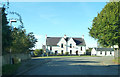
2
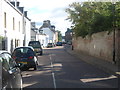
A view along the High Street in Cromarty
The centre of the old coastal town on the Black Isle.
Image: © James Denham
Taken: 2 Sep 2013
0.03 miles
4
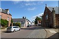
Looking along Cromarty High Street
Also part of the A832.
Image: © DS Pugh
Taken: 6 Sep 2015
0.05 miles
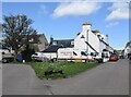
5
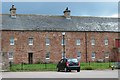
Marine Terrace Hemp Works, Cromarty
The striking complex of buildings dates from ca. 1773 and is now converted to residential use. B-listed: LB23702 http://portal.historicenvironment.scot/designation/LB23702 .
Image: © Bill Harrison
Taken: 16 Apr 2022
0.05 miles
7
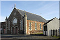
Victoria Hall, High Street, Cromarty
Image: © Tom Richardson
Taken: 29 Oct 2008
0.05 miles
9
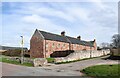
Former hemp works Cromarty
Part of the central section of the three sided [formerly a quadrangle] group of sandstone buildings dating from 1773 and now grade 'B' listed. originally a hemp works, but now converted to dwellings.
Image: © Gordon Hatton
Taken: 3 Jul 2019
0.05 miles
10
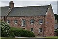
Cromarty: A small part of "The Byre", Marine Terrace
Image: © Michael Garlick
Taken: 26 Jun 2016
0.05 miles