IMAGES TAKEN NEAR TO
Crawford Avenue, FORTROSE, IV10 8UX
Introduction
This page details the photographs taken nearby to Crawford Avenue, IV10 8UX by members of the Geograph project.
The Geograph project started in 2005 with the aim of publishing, organising and preserving representative images for every square kilometre of Great Britain, Ireland and the Isle of Man.

There are currently over 7.5m images from over14,400 individuals and you can help contribute to the project by visiting https://www.geograph.org.uk
Image Map (Loading...)


Getting Data...Please wait
Leaflet Map data © OpenStreetMap
Images are licensed for reuse under creativecommons.org/licenses/by-sa/2.0
Notes
- Clicking on the map will re-center to the selected point.
- The higher the marker number, the further away the image location is from the centre of the postcode.
Image Listing (19 Images Found)
Images are licensed for reuse under creativecommons.org/licenses/by-sa/2.0
Image
Details
Distance
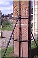
1
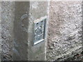
Ordnance Survey Flush Bracket G4540
This mark can be found on the wall of the Old Manse.
For more detail see : http://www.bench-marks.org.uk/bm17298
Image: © Peter Wood
Taken: 30 Sep 2012
0.04 miles
2
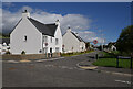
New houses, Rosemarkie
A new housing development, off Courthill Road. This was the site of Greenside Farm.
Image: © Craig Wallace
Taken: 9 Sep 2023
0.06 miles
3
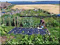
Rosemarkie Allotments
A beautiful place for an allotment with a wide variety of crops being cultivated. Unfortunately there was evidence of blight on the potatoes so most potato foliage would need to be removed as soon as possible.
Image: © Julian Paren
Taken: 18 Aug 2012
0.09 miles
6
Rosemarkie Stone
A beautifully carved Class 2 sculptured sandstone slab, one of several found in Easter Ross.
Image: © Anne Burgess
Taken: Unknown
0.14 miles
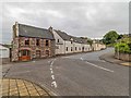
7
Manse Brae Rosemarkie
Looking over the A832 Manse Brae towards Fort George on the far side of the Moray Firth
Image: © valenta
Taken: 12 Jul 2019
0.15 miles
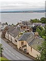
8
Manse Brae Rosemarkie
The A832 Manse Brae, Hawkhill Road branching off to the left. The red sandstone building on the left of the image was the old Miller's Hotel, and now known as Miller's Arch
Image: © valenta
Taken: 12 Jul 2019
0.19 miles

10
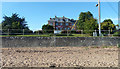
Marine House, Rosemarkie
Viewed from the beach,this used to be a care home.as a Care Home. For sale at time of Photograph.
Image: © Peter Bond
Taken: 13 Oct 2015
0.23 miles