IMAGES TAKEN NEAR TO
Station Crescent, FORTROSE, IV10 8SZ
Introduction
This page details the photographs taken nearby to Station Crescent, IV10 8SZ by members of the Geograph project.
The Geograph project started in 2005 with the aim of publishing, organising and preserving representative images for every square kilometre of Great Britain, Ireland and the Isle of Man.

There are currently over 7.5m images from over14,400 individuals and you can help contribute to the project by visiting https://www.geograph.org.uk
Image Map
Images are licensed for reuse under creativecommons.org/licenses/by-sa/2.0
Notes
- Clicking on the map will re-center to the selected point.
- The higher the marker number, the further away the image location is from the centre of the postcode.
Image Listing (155 Images Found)
Images are licensed for reuse under creativecommons.org/licenses/by-sa/2.0
Image
Details
Distance
1
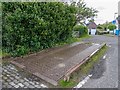
Pooley Weighbridge
On the site of the former Muir-of-Ord to Fortrose Railway, in what would have been the old goods yard, this old railway weighbridge made by Henry Pooley and Son of Liverpool is still in position. I am told the weighbridge office is still intact, with all the workings in situ hidden behind the mass of out of control ivy covering the building.
Image: © valenta
Taken: 27 Apr 2017
0.06 miles
2
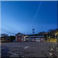
Fortrose Fire Station
Located at the junction of Station Crescent and Station Road, an aircraft contrail visible in the dusk sky
Image: © valenta
Taken: 30 Nov 2019
0.07 miles
3
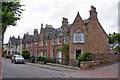
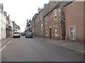
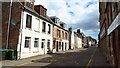
Houses in Fortrose High Street
A Category B listed terrace of three large Gothic-style houses built by John Rhind in 1869.
Image: © Richard Dorrell
Taken: 9 Jul 2020
0.07 miles
4
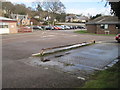
Fortrose railway station (site), Highland
Opened in 1894 as the terminus of the Highland Railway's branch line from Muir of Ord, this station closed in 1951 to passengers and completely in 1960.
View north across the old station forecourt towards the end of the platform and the buffers, with the station building having been to the extreme left. The former weighbridge in the foreground appears to be the only visible evidence of what was here before.
Image: © Nigel Thompson
Taken: 31 Mar 2015
0.08 miles
5
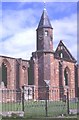
Fortrose Cathedral
This cathedral, like many another, was allowed to fall into disrepair after the Reformation.
Image: © Anne Burgess
Taken: Unknown
0.08 miles
7
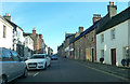
Fortrose on the Black Isle
The High Street.
Image: © James Denham
Taken: 2 Sep 2013
0.09 miles
10
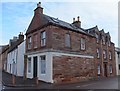
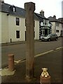
Mercat Cross, Fortrose
The Mercat (Market) Cross in the Royal Burgh of Fortrose stands on the corner of Academy Street and High Street. The Canmore website of the Royal Commission on the Ancient and Historical Monuments of Scotland (RCAHMS) suggests that the cross may date to about 1590 when the town became a royal burgh. A photograph on the site taken in 1961 shows that the ground floor of the building on the corner was formerly occupied by a butcher's shop.
Image: © Alpin Stewart
Taken: 9 Mar 2014
0.09 miles