IMAGES TAKEN NEAR TO
Ness Way, FORTROSE, IV10 8SS
Introduction
This page details the photographs taken nearby to Ness Way, IV10 8SS by members of the Geograph project.
The Geograph project started in 2005 with the aim of publishing, organising and preserving representative images for every square kilometre of Great Britain, Ireland and the Isle of Man.

There are currently over 7.5m images from over14,400 individuals and you can help contribute to the project by visiting https://www.geograph.org.uk
Image Map (Loading...)


Getting Data...Please wait
Leaflet Map data © OpenStreetMap
Images are licensed for reuse under creativecommons.org/licenses/by-sa/2.0
Notes
- Clicking on the map will re-center to the selected point.
- The higher the marker number, the further away the image location is from the centre of the postcode.
Image Listing (24 Images Found)
Images are licensed for reuse under creativecommons.org/licenses/by-sa/2.0
Image
Details
Distance
1
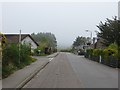
Ness Road
The road out to Chanonry Point.
Image: © Richard Webb
Taken: 27 Apr 2014
0.06 miles
3
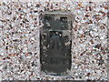
Ordnance Survey Flush Bracket G4539
This can be found on the roadside wall of Chevron Cottage.
For more detail see : http://www.bench-marks.org.uk/bm17325
Image: © Peter Wood
Taken: 30 Sep 2012
0.07 miles
4
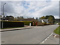
Fortrose : Ness Road
Looking along Ness Road from the junction with Ness Road East.
Image: © Lewis Clarke
Taken: 23 Apr 2016
0.08 miles
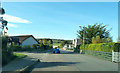
5
Junction of Wester Greengate & Ness Road
Wester Greengate runs alongside the Moray Firth and is blessed with a caravan park. Finally it turns sharply northeast to join the road to Chanonry Point.
Image: © Stuart Logan
Taken: 29 May 2011
0.08 miles
6
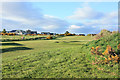
Fortrose and Rosemarkie Golf Course
This is the western extent of the course which occupies most of Chanonry Ness.
Image: © Peter Church
Taken: 1 Jun 2013
0.08 miles
7
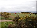
Fortrose : Fortrose & Rosemarkie Golf Club
People playing golf on the course.
Image: © Lewis Clarke
Taken: 23 Apr 2016
0.13 miles
8
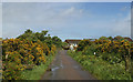
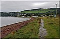
Track to Chanonry Point
This well marked path runs, initially through gorse bushes, down to the parking area at the tip of Chanonry Ness.
Image: © Peter Church
Taken: 1 Jun 2013
0.13 miles
10
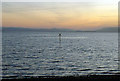
Marine marker off Fortrose
The sun had set, a wind had started up after a very calm day, and a cold frosty night was in prospect. There was no indication of what lay beneath the marker or what extended out to it from the shore despite it being low tide.
Image: © Julian Paren
Taken: 1 Feb 2012
0.17 miles