IMAGES TAKEN NEAR TO
Foxglove Road, IP9 2YF
Introduction
This page details the photographs taken nearby to Foxglove Road, IP9 2YF by members of the Geograph project.
The Geograph project started in 2005 with the aim of publishing, organising and preserving representative images for every square kilometre of Great Britain, Ireland and the Isle of Man.

There are currently over 7.5m images from over14,400 individuals and you can help contribute to the project by visiting https://www.geograph.org.uk
Image Map
Images are licensed for reuse under creativecommons.org/licenses/by-sa/2.0
Notes
- Clicking on the map will re-center to the selected point.
- The higher the marker number, the further away the image location is from the centre of the postcode.
Image Listing (27 Images Found)
Images are licensed for reuse under creativecommons.org/licenses/by-sa/2.0
Image
Details
Distance
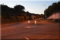
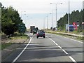
4
Under the A12
The route under this bridge on the A12 allows local access to and from Bentley and Capel St Mary.
Image: © Roger Jones
Taken: 12 Jun 2011
0.20 miles
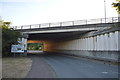
6
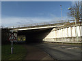
A12 Bridge over The Street
At the junction with Ipswich Road
Image: © Geographer
Taken: 5 Feb 2014
0.21 miles
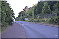
7
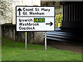
Roadsign on The Street
At the junction with Ipswich Road near the A12 Bridge
Image: © Geographer
Taken: 5 Feb 2014
0.21 miles
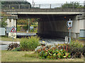
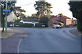
8
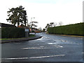
The Street, Capel St.Mary
At the junction with London Road
Image: © Geographer
Taken: 5 Feb 2014
0.21 miles
10
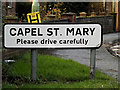
Capel St Mary sign
On The Street at the junction with London Road
Image: © Geographer
Taken: 5 Feb 2014
0.22 miles