IMAGES TAKEN NEAR TO
St. Andrews Drive, IPSWICH, IP9 1HU
Introduction
This page details the photographs taken nearby to St. Andrews Drive, IP9 1HU by members of the Geograph project.
The Geograph project started in 2005 with the aim of publishing, organising and preserving representative images for every square kilometre of Great Britain, Ireland and the Isle of Man.

There are currently over 7.5m images from over14,400 individuals and you can help contribute to the project by visiting https://www.geograph.org.uk
Image Map
Images are licensed for reuse under creativecommons.org/licenses/by-sa/2.0
Notes
- Clicking on the map will re-center to the selected point.
- The higher the marker number, the further away the image location is from the centre of the postcode.
Image Listing (35 Images Found)
Images are licensed for reuse under creativecommons.org/licenses/by-sa/2.0
Image
Details
Distance
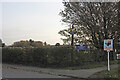
2
Chelmondiston and Pin Mill village sign
The proximity of the Orwell is not obvious when driving through on the B1456, but the sign acts as a reminder.
Image: © Andrew Hill
Taken: 7 Aug 2009
0.07 miles
4
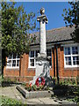
Chelmondiston War Memorial
The Memorial bears the names of 24 men lost in WW1 and 3 lost in WW2. The death of one civilian is also recorded on the Memorial in the church.
Image: © Adrian S Pye
Taken: 27 May 2015
0.09 miles
5
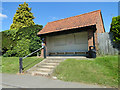
Bus shelter
I wonder why it's not called a passenger shelter because buses don't use them.
Image: © Adrian S Pye
Taken: 27 May 2015
0.09 miles
6
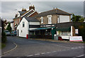
Shop at the corner of Church Street
Chelmondiston boasts a surprisingly large looking butcher's shop.
Image: © Andrew Hill
Taken: 7 Aug 2009
0.09 miles
7
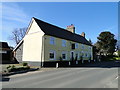
The 'Red Lion' at Chelmondiston
http://www.geograph.org.uk/photo/5318744
Image: © Adrian S Pye
Taken: 21 Mar 2017
0.09 miles
8
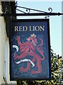
The sign of the 'Red Lion' at Chelmondiston
http://www.geograph.org.uk/photo/5318743
Image: © Adrian S Pye
Taken: 21 Mar 2017
0.09 miles
9
Chelmondiston and Pin Mill village sign
In the hedge which surrounds the school playing field.
See a close up and more about the sign here https://www.geograph.org.uk/photo/6650987
Image: © Adrian S Pye
Taken: 24 Oct 2020
0.11 miles
10
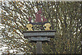
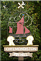
Chelmondiston and Pin Mill village sign
Pin Mill is a waterside hamlet of Chelmondiston. A red sail of a London sailing barge often seen racing at Pin Mill dominates the sign. The film “Ha'penny Breeze” was shot entirely at Pin Mill in 1950. Arthur Ransome lived in Pin Mill and used the river as his setting for the Swallows & Amazons.
Two sheaves of corn below represent the more agricultural Chelmondiston. The windmill at the very top is broken and the sails flail in the breeze.
Image: © Adrian S Pye
Taken: 24 Oct 2020
0.11 miles