1
Uncommon or garden pump #2
Jonets Patent pump, made by the Safety Water Elevator Co. of Dunstable, and using a series of buckets on a chain. See also http://www.villagepumps.org.uk/manufs.htm
http://www.geograph.org.uk/photo/4621198
Image: © Adrian S Pye
Taken: 19 Aug 2015
0.01 miles
2
Uncommon or garden pump
A Jonets Patent pump, made by the Safety Water Elevator Co of Dunstable, and using a series of buckets on a chain. Very few of them about. Read more at
http://www.villagepumps.org.uk/manufs.htm
http://www.geograph.org.uk/photo/4621596
Image: © Adrian S Pye
Taken: 19 Aug 2015
0.02 miles
3
Chattisham Telephone Box
On The Street
Image: © Geographer
Taken: 23 Feb 2009
0.03 miles
4
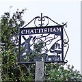
Chattisham Village Sign
On The Street
Image: © Geographer
Taken: 23 Feb 2009
0.06 miles
5
Chattisham Village Sign
On The Street
(Close up)
Image: © Geographer
Taken: 23 Feb 2009
0.06 miles
6
Chattisham village sign obscured by a conifer
The silhouette style sign is based on a map of the village with a bit of Hintlesham and the A1071, thrown in for good measure. The smock mill used to stand about 400 yards north of the church on Chattisham Lane. Chattisham Hall, on centre right, is also featured. At the bottom is The Clays, the oldest house in the parish and only a few yards from this sign, and of course, the church of All Saints & St Margaret.
Image: © Adrian S Pye
Taken: 30 Aug 2007
0.06 miles
7
Chattisham village sign and seat
Details of the sign can be seen here https://www.geograph.org.uk/photo/6780666
Image: © Adrian S Pye
Taken: 19 Aug 2015
0.06 miles
8
Chattisham village sign
The silhouette style sign is based on a map of the village with a bit of Hintlesham and the A1071, thrown in for good measure. The smock mill used to stand about 400 yards north of the church on Chattisham Lane. Chattisham Hall, on centre right, is also featured. At the bottom is The Clays, the oldest house in the parish and only a few yards from this sign, and of course, the church of All Saints & St Margaret. https://www.geograph.org.uk/photo/4291607
Image: © Adrian S Pye
Taken: 30 Aug 2007
0.06 miles
9
Corner Farmhouse The Street Victorian Postbox
At The Street road junction
Postbox No.IP8 1094
Image: © Geographer
Taken: 23 Feb 2009
0.07 miles
10
The Street, Chattisham
Looking towards Washbrook
Image: © Geographer
Taken: 23 Feb 2009
0.07 miles


