IMAGES TAKEN NEAR TO
Pearsons Way, IPSWICH, IP8 3LG
Introduction
This page details the photographs taken nearby to Pearsons Way, IP8 3LG by members of the Geograph project.
The Geograph project started in 2005 with the aim of publishing, organising and preserving representative images for every square kilometre of Great Britain, Ireland and the Isle of Man.

There are currently over 7.5m images from over14,400 individuals and you can help contribute to the project by visiting https://www.geograph.org.uk
Image Map
Images are licensed for reuse under creativecommons.org/licenses/by-sa/2.0
Notes
- Clicking on the map will re-center to the selected point.
- The higher the marker number, the further away the image location is from the centre of the postcode.
Image Listing (70 Images Found)
Images are licensed for reuse under creativecommons.org/licenses/by-sa/2.0
Image
Details
Distance
1
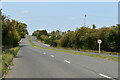
London Road, Washbrook
This stretch of road was formerly part of the A12 and was constructed as the single carriageway Washbrook by-pass in the 1930s and dualled sometime in the 1970s. Before its construction, the route took a sharp bend at Whight's Corner and passed along Chapel Lane, crossing Belstead Brook at Washbrook Bridge.
Image: © Simon Mortimer
Taken: 11 Sep 2020
0.07 miles
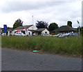
3
Washbrook Service Centre & Washbrook Motorcycles
On London Road
Image: © Geographer
Taken: 14 Jun 2013
0.07 miles
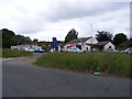
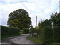
4

Pearsons Way, Washbrook
At the junction with The Street
Image: © Geographer
Taken: 22 Aug 2013
0.07 miles
5

Post Office 1 Pearsons Way Postbox
On The Street at the junction with Pearsons Way
Postbox No.IP8 1203
Image: © Geographer
Taken: 22 Aug 2013
0.07 miles
6

Post Office 1 Pearsons Way Postbox
On The Street at the junction with Pearsons Way
Postbox No.IP8 1203
Image: © Geographer
Taken: 22 Aug 2013
0.07 miles
7

Post Office 1 Pearsons Way Postbox
On The Street at the junction with Pearsons Way
Postbox No.IP8 1203
Image: © Geographer
Taken: 22 Aug 2013
0.07 miles
9
Footpath & entrance to Amor Hall & Brook Barn
Off The Street
Image: © Geographer
Taken: 4 Oct 2013
0.07 miles
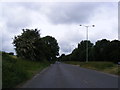
10

The Street, Wasbrook
Looking towards Swan Hill at the junction with Pearsons Way
Image: © Geographer
Taken: 22 Aug 2013
0.07 miles