IMAGES TAKEN NEAR TO
Water Run, IPSWICH, IP7 7LN
Introduction
This page details the photographs taken nearby to Water Run, IP7 7LN by members of the Geograph project.
The Geograph project started in 2005 with the aim of publishing, organising and preserving representative images for every square kilometre of Great Britain, Ireland and the Isle of Man.

There are currently over 7.5m images from over14,400 individuals and you can help contribute to the project by visiting https://www.geograph.org.uk
Image Map
Images are licensed for reuse under creativecommons.org/licenses/by-sa/2.0
Notes
- Clicking on the map will re-center to the selected point.
- The higher the marker number, the further away the image location is from the centre of the postcode.
Image Listing (6 Images Found)
Images are licensed for reuse under creativecommons.org/licenses/by-sa/2.0
Image
Details
Distance
1
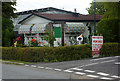
New park homes available
A small development by the B1115 near Hitcham.
Image: © Andrew Hill
Taken: 5 Aug 2009
0.01 miles
2
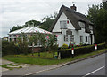
House by the B1115
Near Cross Green which is a continuation of the ribbon development along the road from Hitcham.
Image: © Andrew Hill
Taken: 5 Aug 2009
0.03 miles
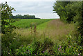
3

Farmland and housing at Water Run
The B1115 links the hamlets of Cross Green and Water Run. This view, from the start of a footpath at Cross Green, shows the farmland east of the B1115. In the distance is a mobile homes park.
Image: © Bob Jones
Taken: 26 Jan 2010
0.12 miles
4

Footpath to Loose Hall
Unusually, this footpath heads due east, almost exactly following the grid line. However, according to Get-a-Map, the photographer is standing just inside the grid square and the first two hundred metres or so is still within the square.
Image: © Bob Jones
Taken: 26 Jan 2010
0.21 miles
5
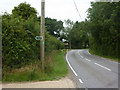
B1115 towards Hitcham
By the start of a couple of footpaths - there are no more paths through to the fields between here and the church.
Image: © Andrew Hill
Taken: 5 Aug 2009
0.22 miles
6
Field east of Knox Farm
South of the path towards Bird Street.
Image: © Andrew Hill
Taken: 5 Aug 2009
0.23 miles