IMAGES TAKEN NEAR TO
Swingleton Hill, IPSWICH, IP7 7AD
Introduction
This page details the photographs taken nearby to Swingleton Hill, IP7 7AD by members of the Geograph project.
The Geograph project started in 2005 with the aim of publishing, organising and preserving representative images for every square kilometre of Great Britain, Ireland and the Isle of Man.

There are currently over 7.5m images from over14,400 individuals and you can help contribute to the project by visiting https://www.geograph.org.uk
Image Map
Images are licensed for reuse under creativecommons.org/licenses/by-sa/2.0
Notes
- Clicking on the map will re-center to the selected point.
- The higher the marker number, the further away the image location is from the centre of the postcode.
Image Listing (16 Images Found)
Images are licensed for reuse under creativecommons.org/licenses/by-sa/2.0
Image
Details
Distance
3
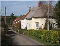
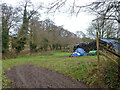
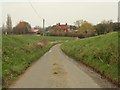
Back Lane
Back Lane Swingleton Green, Suffolk.
Image: © Keith Evans
Taken: 29 Sep 2011
0.08 miles
5
Small field by River Brett
A sort of wood yard.
Image: © Robin Webster
Taken: 24 Dec 2013
0.19 miles
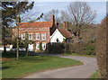
6
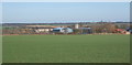
Fields near Milden looking towards Wyncolls Hall Farm
The tower of Monks Eleigh church can be seen above the farm buildings.
Image: © Andrew Hill
Taken: 14 Mar 2008
0.20 miles
7
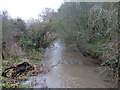
River Brett downstream from Scripcross Bridge
Image: © Robin Webster
Taken: 24 Dec 2013
0.20 miles
8
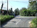
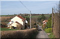
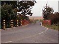
Road Junction
Road junction near to Monks Eleigh, Suffolk.
Image: © Keith Evans
Taken: 29 Sep 2011
0.21 miles
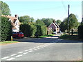
10
Scripcross Bridge
The road that goes over the bridge is the B.1115, which joins the A.1141
Image: © Robert Edwards
Taken: 8 Nov 2006
0.22 miles