IMAGES TAKEN NEAR TO
Ward Close, IPSWICH, IP7 6GF
Introduction
This page details the photographs taken nearby to Ward Close, IP7 6GF by members of the Geograph project.
The Geograph project started in 2005 with the aim of publishing, organising and preserving representative images for every square kilometre of Great Britain, Ireland and the Isle of Man.

There are currently over 7.5m images from over14,400 individuals and you can help contribute to the project by visiting https://www.geograph.org.uk
Image Map
Images are licensed for reuse under creativecommons.org/licenses/by-sa/2.0
Notes
- Clicking on the map will re-center to the selected point.
- The higher the marker number, the further away the image location is from the centre of the postcode.
Image Listing (9 Images Found)
Images are licensed for reuse under creativecommons.org/licenses/by-sa/2.0
Image
Details
Distance
1
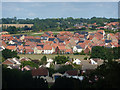
View of new housing estate in Hadleigh
A zoom picture from the path across Constitution Hill.
Image: © Andrew Hill
Taken: 11 Aug 2009
0.11 miles
2
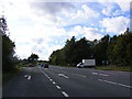
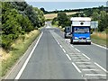
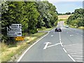
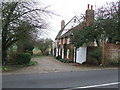
A1071 Ipswich Road, Hadleigh
At the junction with Aldhams Mill Hill
Image: © Geographer
Taken: 4 Oct 2013
0.13 miles
4
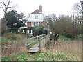
Aldham Mill
Alsham Mill near to Hadleigh, Suffolk.
Image: © Keith Evans
Taken: 29 Jan 2012
0.18 miles
5
Aldham Mill
Aldham Mill near to Hadleigh, Suffolk.
Image: © Keith Evans
Taken: 29 Jan 2012
0.19 miles
6
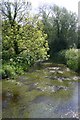
River Brett at Aldham Mill
The River Brett rises near RAF Wattisham. Viewed here from a footbridge, it passes close to Aldham Mill, just north of Hadleigh.
Image: © Bob Jones
Taken: 22 May 2007
0.19 miles
7
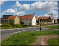
New housing development by Boswell Lane
A new estate filling in some of the space between the town and the A1071 passing to the north.
Image: © Andrew Hill
Taken: 11 Aug 2009
0.20 miles
8
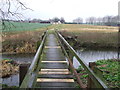
Footbridge
Footbridge across the River Brett near to Hadleigh, Suffolk.
Image: © Keith Evans
Taken: 29 Jan 2012
0.20 miles