IMAGES TAKEN NEAR TO
Water Lane, IPSWICH, IP7 6EJ
Introduction
This page details the photographs taken nearby to Water Lane, IP7 6EJ by members of the Geograph project.
The Geograph project started in 2005 with the aim of publishing, organising and preserving representative images for every square kilometre of Great Britain, Ireland and the Isle of Man.

There are currently over 7.5m images from over14,400 individuals and you can help contribute to the project by visiting https://www.geograph.org.uk
Image Map
Images are licensed for reuse under creativecommons.org/licenses/by-sa/2.0
Notes
- Clicking on the map will re-center to the selected point.
- The higher the marker number, the further away the image location is from the centre of the postcode.
Image Listing (8 Images Found)
Images are licensed for reuse under creativecommons.org/licenses/by-sa/2.0
Image
Details
Distance
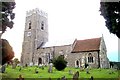
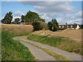
2
Field And Footpath
Field and footpath near to Kersey, Suffolk.
Image: © Keith Evans
Taken: 17 Oct 2010
0.19 miles

5
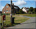
Houses south of Kersey church
There are quite a number of houses on the dead end lane south of the church. The local postbox is also in view.
Image: © Andrew Hill
Taken: 5 Sep 2009
0.21 miles
6
Towards the top of Vale Lane
The house at the southern end of the village now come into view.
Image: © Andrew Hill
Taken: 5 Sep 2009
0.22 miles
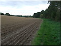
7
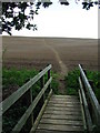
Footpath And Bridge
Clearly marked footpath and bridge near to Kersey, Suffolk.
Image: © Keith Evans
Taken: 17 Oct 2010
0.24 miles
