IMAGES TAKEN NEAR TO
Schoorl Close, IPSWICH, IP7 5SP
Introduction
This page details the photographs taken nearby to Schoorl Close, IP7 5SP by members of the Geograph project.
The Geograph project started in 2005 with the aim of publishing, organising and preserving representative images for every square kilometre of Great Britain, Ireland and the Isle of Man.

There are currently over 7.5m images from over14,400 individuals and you can help contribute to the project by visiting https://www.geograph.org.uk
Image Map
Images are licensed for reuse under creativecommons.org/licenses/by-sa/2.0
Notes
- Clicking on the map will re-center to the selected point.
- The higher the marker number, the further away the image location is from the centre of the postcode.
Image Listing (15 Images Found)
Images are licensed for reuse under creativecommons.org/licenses/by-sa/2.0
Image
Details
Distance
1
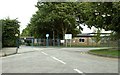
Hadleigh High School, Hadleigh, Suffolk
Image: © Robert Edwards
Taken: 30 Aug 2006
0.11 miles
2

End Of The Road
The end of Frog Hall Lane for motorised traffic at Hadleigh, Suffolk.
Image: © Keith Evans
Taken: 17 Oct 2010
0.12 miles
3

Chapel building, Hadleigh
I'm not sure if this is still in use as a place of worship, or if it has been, or is in the process of being, converted to non-religious use.
Image: © Oxymoron
Taken: 25 Jun 2009
0.21 miles
4
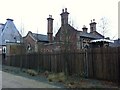
Former Hadleigh Station
Hadleigh railway station was opened in 1847 and closed to passenger traffic in 1932, with freight services lasting on until 1965 now a rather swanky home
Image: © Oxyman
Taken: 5 Jan 2011
0.21 miles

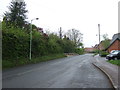
6
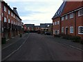
The end of George Street
Any through traffic needs to turn left along The Green. Straight ahead the road is named Tower Mill Lane and soon turns into a farm track.
Image: © Andrew Hill
Taken: 11 Aug 2009
0.22 miles
8
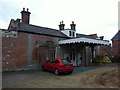
Former Hadleigh Station
Hadleigh railway station was opened in 1847 and closed to passenger traffic in 1932, with freight services lasting on until 1965 now a rather swanky home
Image: © Oxyman
Taken: 5 Jan 2011
0.22 miles
9
Former Hadleigh Station
Hadleigh railway station was opened in 1847 and closed to passenger traffic in 1932, with freight services lasting on until 1965 now a rather swanky home
Image: © Oxyman
Taken: 5 Jan 2011
0.23 miles
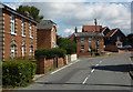
10
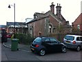
Station Yard, Hadleigh
For some reason Google street view has blanked out the name of this cul-de-sac on its images. The Former Hadleigh Station can be seen on the right.
Image: © Oxyman
Taken: 5 Jan 2011
0.23 miles