IMAGES TAKEN NEAR TO
Shrubland Park, IPSWICH, IP6 9QJ
Introduction
This page details the photographs taken nearby to Shrubland Park, IP6 9QJ by members of the Geograph project.
The Geograph project started in 2005 with the aim of publishing, organising and preserving representative images for every square kilometre of Great Britain, Ireland and the Isle of Man.

There are currently over 7.5m images from over14,400 individuals and you can help contribute to the project by visiting https://www.geograph.org.uk
Image Map (Loading...)


Getting Data...Please wait
Leaflet Map data © OpenStreetMap
Images are licensed for reuse under creativecommons.org/licenses/by-sa/2.0
Notes
- Clicking on the map will re-center to the selected point.
- The higher the marker number, the further away the image location is from the centre of the postcode.
Image Listing (9 Images Found)
Images are licensed for reuse under creativecommons.org/licenses/by-sa/2.0
Image
Details
Distance
1
Part of driveway to the Hall in Shrubland Park
Image: © Andrew Hill
Taken: 30 Oct 2007
0.08 miles
4
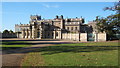
Shrubland Hall
The grounds are a former medieval deer park. The main house dates from the 18th century. From 1965 to 2006 it was a health clinic opened by the sixth Baron de Saumarez and his wife.
Image: © Andrew Hill
Taken: 30 Oct 2007
0.15 miles
7
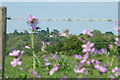
Shrubland Hall seen across fields
Despite its hilltop location, Shrubland Hall is surrounded by trees and not visible from public areas around the estate. However along the road north out of Great Blakenham there are several places like this where it can be seen. Maybe the hall has that tower so that the owners can also see out of their estate. In the space between the camera and the hall there is the busy dual carriageway A14 road and the main east/west rail line.
Image: © John Goldsmith
Taken: 29 Jun 2009
0.21 miles
8
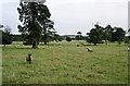
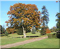
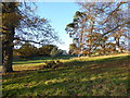
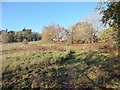
Parkland, Great Blakenham
Shrubland Park, largely laid out in the late C18th and early C19th. Humphry Repton worked here.
The date of the photo is uncertain.
Image: © Stephen Richards
Taken: Unknown
0.21 miles