IMAGES TAKEN NEAR TO
Creeting St. Mary, IPSWICH, IP6 8QF
Introduction
This page details the photographs taken nearby to IP6 8QF by members of the Geograph project.
The Geograph project started in 2005 with the aim of publishing, organising and preserving representative images for every square kilometre of Great Britain, Ireland and the Isle of Man.

There are currently over 7.5m images from over14,400 individuals and you can help contribute to the project by visiting https://www.geograph.org.uk
Image Map
Images are licensed for reuse under creativecommons.org/licenses/by-sa/2.0
Notes
- Clicking on the map will re-center to the selected point.
- The higher the marker number, the further away the image location is from the centre of the postcode.
Image Listing (7 Images Found)
Images are licensed for reuse under creativecommons.org/licenses/by-sa/2.0
Image
Details
Distance
1
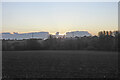
Upper Langdales Farm from Chips Thatch
Sun just rising over the clouds
Image: © Adrian S Pye
Taken: 26 Oct 2020
0.06 miles
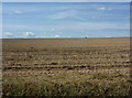
2
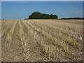
Stalks left in harvested field
The crop rows can be seen as a temporary feature between harvesting and ploughing.
Image: © Andrew Hill
Taken: 31 Jul 2009
0.08 miles
4
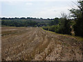
Looking towards Fen Lane
The large recently harvested field stretches right down to the lane.
Image: © Andrew Hill
Taken: 31 Jul 2009
0.13 miles
5
Harvested field
Tractors were working the field as I walked past.
Image: © Andrew Hill
Taken: 31 Jul 2009
0.16 miles
6
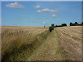
Footpath between harvested fields
Looking up a gentle slope from Fen Lane. Distant tractors show the scale.
Image: © Andrew Hill
Taken: 31 Jul 2009
0.17 miles
7
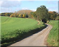
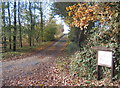
Looking up Mill Lane from the junction with Fen Lane
Both lanes named on OS 25,000 map.
Image: © Andrew Hill
Taken: 29 Oct 2007
0.21 miles