IMAGES TAKEN NEAR TO
Old Ipswich Road, IPSWICH, IP6 0AE
Introduction
This page details the photographs taken nearby to Old Ipswich Road, IP6 0AE by members of the Geograph project.
The Geograph project started in 2005 with the aim of publishing, organising and preserving representative images for every square kilometre of Great Britain, Ireland and the Isle of Man.

There are currently over 7.5m images from over14,400 individuals and you can help contribute to the project by visiting https://www.geograph.org.uk
Image Map
Images are licensed for reuse under creativecommons.org/licenses/by-sa/2.0
Notes
- Clicking on the map will re-center to the selected point.
- The higher the marker number, the further away the image location is from the centre of the postcode.
Image Listing (51 Images Found)
Images are licensed for reuse under creativecommons.org/licenses/by-sa/2.0
Image
Details
Distance

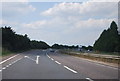
5
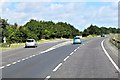
Northbound A14, Exit at Junction 52 (Claydon Roundabout)
Image: © David Dixon
Taken: 3 Aug 2013
0.11 miles
7
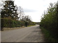
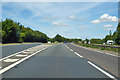
Old Ipswich Road
This section of road was bypassed in the early 1980s when the dual carriageway (now designated the A14) was built and now comes to a dead end near Hill View Farm.
Image: © Chris Holifield
Taken: 6 Apr 2012
0.12 miles

9
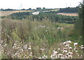
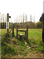
Overgrown field corner
View from a footpath tracing an interesting route round the back of Claydon village to the church.
Image: © Andrew Hill
Taken: 23 Aug 2008
0.14 miles
10
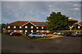
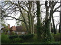
Premier Inn, Ipswich North (off Paper Mill Lane, Claydon)
Image: © Christopher Hilton
Taken: 8 Jul 2017
0.14 miles