IMAGES TAKEN NEAR TO
Foxhall Road, IPSWICH, IP4 5SW
Introduction
This page details the photographs taken nearby to Foxhall Road, IP4 5SW by members of the Geograph project.
The Geograph project started in 2005 with the aim of publishing, organising and preserving representative images for every square kilometre of Great Britain, Ireland and the Isle of Man.

There are currently over 7.5m images from over14,400 individuals and you can help contribute to the project by visiting https://www.geograph.org.uk
Image Map
Images are licensed for reuse under creativecommons.org/licenses/by-sa/2.0
Notes
- Clicking on the map will re-center to the selected point.
- The higher the marker number, the further away the image location is from the centre of the postcode.
Image Listing (24 Images Found)
Images are licensed for reuse under creativecommons.org/licenses/by-sa/2.0
Image
Details
Distance
1
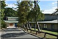
Nuffield Health Ipswich Hospital
This private hospital opened in 1997 and was built on the site of Foxhall Hospital, the former TB sanatorium that opened in 1912 and closed in 1975.
Image: © Simon Mortimer
Taken: 10 Sep 2020
0.02 miles
2
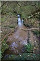
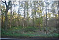
Stream between Brook Hill and Brookhill Wood
This stream flows south east from the Foxhall Road to Purdis Farm, then east into the River Deben. There are board walks beside it as the ground can be very swampy.
Image: © steve
Taken: 5 Nov 2005
0.13 miles