IMAGES TAKEN NEAR TO
Westbury Avenue, BURY ST. EDMUNDS, IP33 3PZ
Introduction
This page details the photographs taken nearby to Westbury Avenue, IP33 3PZ by members of the Geograph project.
The Geograph project started in 2005 with the aim of publishing, organising and preserving representative images for every square kilometre of Great Britain, Ireland and the Isle of Man.

There are currently over 7.5m images from over14,400 individuals and you can help contribute to the project by visiting https://www.geograph.org.uk
Image Map
Images are licensed for reuse under creativecommons.org/licenses/by-sa/2.0
Notes
- Clicking on the map will re-center to the selected point.
- The higher the marker number, the further away the image location is from the centre of the postcode.
Image Listing (59 Images Found)
Images are licensed for reuse under creativecommons.org/licenses/by-sa/2.0
Image
Details
Distance
1
West Road
All Over Beauty in West Road, Bury St. Edmunds, Suffolk closed today as it being Christmas Day 2013.
Image: © Keith Evans
Taken: 25 Dec 2013
0.05 miles
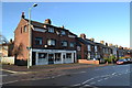
2
West Road Church
West Road Church on the corner of West Road and Queens Road Bury St.Edmunds Suffolk.
Image: © Keith Evans
Taken: 24 May 2008
0.07 miles
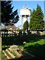
3
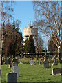
The Water Tower
Bury St.Edmunds water tower as viewed from the cemetery Bury St.Edmunds Suffolk.
Image: © Keith Evans
Taken: 17 Dec 2006
0.11 miles
4
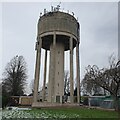
Water Tower, West Road, Bury St Edmunds
A delightful example of functional but not necessarily aesthetically pleasing concrete (with phone masts) from 1951-2 http://www.stedmundsburychronicle.co.uk/watertower.htm
Image: © Richard Rogerson
Taken: 18 Dec 2022
0.12 miles
5
Water Tower on West Road, Bury St Edmunds, taken from the cemetery.
The water tower, situated on one of the highest points in Bury, can be seen from many parts of the town. Not a particularly beautiful structure and made worse by the myriad array of masts, transmitters and aerials on it.
Image: © chris spencer
Taken: 1 Apr 2009
0.12 miles
6
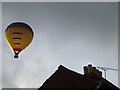
Evening Flight
Hot air balloon seen early evening over Bury St.Edmunds, Suffolk.
Image: © Keith Evans
Taken: 8 Aug 2009
0.13 miles
7
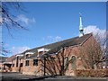
Bury St Edmunds, All Saints church
All Saints is situated next door to the C of E primary school surrounded by houses in the west of the town a few hundred yard west of the cemetery
Image: © Adrian S Pye
Taken: 25 Aug 2007
0.13 miles
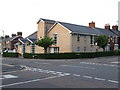
8
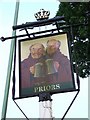
The Priors sign
The pub sign of the Priors Bury St. Edmunds Suffolk. For view of the pub see http://www.geograph.org.uk/photo/815574
Image: © Keith Evans
Taken: 24 May 2008
0.17 miles
9
![Bury St Edmunds features [48]](https://s2.geograph.org.uk/geophotos/06/70/47/6704730_05f8ed81_120x120.jpg)
Bury St Edmunds features [48]
A general view of Bury St Edmunds Cemetery, seen from near the chapel Image
Much of the centre of the town has suffered from redevelopment and most buildings are later than the mid 19th century. There are some uninspiring modern buildings along Parkway and the Arc shopping centre is particularly ugly, especially the building occupied by Debenhams.
Bury St Edmunds is a market town which is the cultural and retail centre for West Suffolk and is known for brewing (Greene King) and sugar (British Sugar). There is scattered evidence of earlier activity but essentially Bury St Edmunds began as one of the royal boroughs of the Saxons and a monastery was founded which became the burial place of King Edmund. A new Benedictine abbey was built in 1020 which became rich and powerful and the town was laid out on a grid pattern by Abbot Baldwin. After the dissolution the abbey became ruinous. A new church, later the cathedral, was begun in the early 16th century.
Image: © Michael Dibb
Taken: 11 Sep 2020
0.17 miles
10
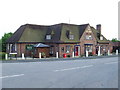
The Priors
The Priors public house Bury St.Edmunds Suffolk.For close up of the sign see http://www.geograph.org.uk/photo/815581
Image: © Keith Evans
Taken: 24 May 2008
0.17 miles